Vas geodata
Vas (Veneto) is a seat of a third-order administrative division; located in Italy in Europe/Rome (GMT+2) time zone. With population of 487 people, there are 9972 cities with bigger population in this country. Compared to other cities in Italy, 90.2% of cities are located further ↓South; 55% of cities are located further ←West and 53% of cities have higher elevation than Vas. Note1


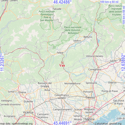
Vas GPS coordinates[2]
45° 56' 16.944" North, 11° 56' 8.844" East
| Map corner | latitude | longitude |
|---|---|---|
| Upper-left | 46.42486°, | 11.23267° |
| Center: | 45.93804°, | 11.93579° |
| Lower-right: | 45.44691°, | 12.63892° |
| Map W x H: | 108.7×108.7 km | = 67.5×67.5mi |
| max Lat: | 47.04031° ⇑9.8% North |
| Vas: | 45.93804° |
| min Lat: | ⇓90.2% South 35.50142° |
| min Long | Vas | max Long |
| 6.69888° | 11.93579° | 18.48682° |
| W 55%⇐ | ⇒45% E |
Elevation
Elevation of Vas is 216 m = 709 ft, and this is 90.7 m = 298 ft below average elevation for this country.
| Max E: |
2085 m = 6841 ft | 53% |
| Avg. | 306.7 m = 1006 ft | |
| Vas | 216 m = 709 ft | |
Min E: |
-4 m = -13 ft | 47% |
See also: Italy elevation on elevation.city.
Geographical zone
Vas is located in North temperate zone (between Tropic of Cancer and the Arctic Circle). Distance of this North polar circle is 2293.3 km =1425 mi to North.| Distance of | km | miles | from Vas |
|---|---|---|---|
| North Pole | 4899.2 | 3044.2 | to North |
| Arctic Circle | 2293.3 | 1425 | to North |
| Tropic Cancer | 2501.9 | 1554.6 | to South |
| Equator | 5107.8 | 3173.8 | to South |


Nearby cities:
15 places around Vas: (largest is in red/bold)
• Alano di Piave
4.1 km =2.5 mi,  211°
211°
• Anzù
7.9 km =4.9 mi,  358°
358°
• Bigolino
10.1 km =6.3 mi,  141°
141°
• Caniezza
9.9 km =6.2 mi,  196°
196°
• Cavaso del Tomba
9.1 km =5.7 mi, 198°
• Colmirano
3.5 km =2.2 mi,  177°
177°
• Feltre
9.6 km =6 mi,  343°
343°
• Guia
9.9 km =6.2 mi,  108°
108°
• Onigo
10 km =6.2 mi,  154°
154°
• Pederobba
7 km =4.3 mi,  171°
171°
• Possagno
10.8 km =6.7 mi, 201°
• Quero
1.9 km =1.2 mi,  189°
189°
• Segusino
2.8 km =1.7 mi, 146°
• Seren del Grappa
8.9 km =5.5 mi,  316°
316°
• Valdobbiadene
5.8 km =3.6 mi, 141°
Sources, notices
• [Note1] Compared only with cities in Italy existing in our database
• [Src1] Map data: © OpenStreetMap contributors (CC-BY-SA)
• [Src2] Other city data from geonames.org with taken over terms of usage.
• [Src3] Geographical zone / Annual Mean Temperature by Robert A. Rohde @ Wikipedia
