Vadena geodata
Vadena (Trentino-Alto Adige) is a seat of a third-order administrative division; located in Italy in Europe/Rome (GMT+2) time zone. With population of 44 people, there are 11617 cities with bigger population in this country. Compared to other cities in Italy, 97.8% of cities are located further ↓South; 53% of cities are located further →East and 51.4% of cities have higher elevation than Vadena. Note1


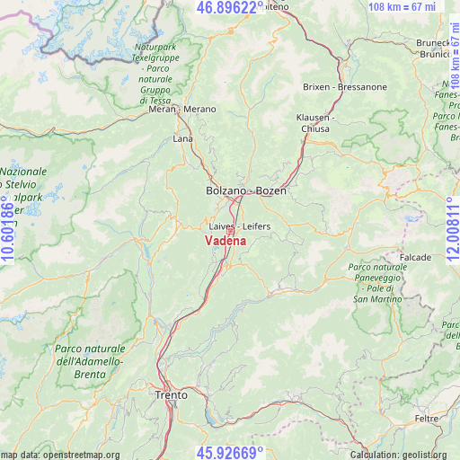
Vadena GPS coordinates[2]
46° 24' 48.996" North, 11° 18' 17.928" East
| Map corner | latitude | longitude |
|---|---|---|
| Upper-left | 46.89622°, | 10.60186° |
| Center: | 46.41361°, | 11.30498° |
| Lower-right: | 45.92669°, | 12.00811° |
| Map W x H: | 107.8×107.8 km | = 67×67mi |
| max Lat: | 47.04031° ⇑2.2% North |
| Vadena: | 46.41361° |
| min Lat: | ⇓97.8% South 35.50142° |
| min Long | Vadena | max Long |
| 6.69888° | 11.30498° | 18.48682° |
| W 47%⇐ | ⇒53% E |
Elevation
Elevation of Vadena is 225 m = 738 ft, and this is 81.7 m = 268 ft below average elevation for this country.
| Max E: |
2085 m = 6841 ft | 51.4% |
| Avg. | 306.7 m = 1006 ft | |
| Vadena | 225 m = 738 ft | |
Min E: |
-4 m = -13 ft | 48.6% |
See also: Italy elevation on elevation.city.
Geographical zone
Vadena is located in North temperate zone (between Tropic of Cancer and the Arctic Circle). Distance of this North polar circle is 2240.5 km =1392.2 mi to North.| Distance of | km | miles | from Vadena |
|---|---|---|---|
| North Pole | 4846.4 | 3011.4 | to North |
| Arctic Circle | 2240.5 | 1392.2 | to North |
| Tropic Cancer | 2554.8 | 1587.5 | to South |
| Equator | 5160.7 | 3206.7 | to South |


Nearby cities:
15 places around Vadena: (largest is in red/bold)
• Aldino
6.6 km =4.1 mi,  144°
144°
• Bolzano
9 km =5.6 mi,  17°
17°
• Bronzolo
1.7 km =1.1 mi,  132°
132°
• Caldaro sulla Strada del Vino
4.5 km =2.8 mi,  269°
269°
• Cornaiano
5.8 km =3.6 mi,  341°
341°
• Laives
3 km =1.9 mi,  60°
60°
• Montagna
9.3 km =5.8 mi,  182°
182°
• Nova Ponente
9.2 km =5.7 mi,  89°
89°
• Ora
7.4 km =4.6 mi, 184°
• Pineta
4.4 km =2.7 mi,  47°
47°
• Ruffrè
9.8 km =6.1 mi, 270°
• San Giacomo
5.2 km =3.2 mi, 24°
• San Michele
5.6 km =3.5 mi,  324°
324°
• San Paolo
7.3 km =4.5 mi,  332°
332°
• Termeno
9.3 km =5.8 mi,  210°
210°
Sources, notices
• [Note1] Compared only with cities in Italy existing in our database
• [Src1] Map data: © OpenStreetMap contributors (CC-BY-SA)
• [Src2] Other city data from geonames.org with taken over terms of usage.
• [Src3] Geographical zone / Annual Mean Temperature by Robert A. Rohde @ Wikipedia
