Ora geodata
Ora (Trentino-Alto Adige) is a seat of a third-order administrative division; located in Italy in Europe/Rome (GMT+2) time zone. With population of 3,198 people, there are 2898 cities with bigger population in this country. Compared to other cities in Italy, 97.3% of cities are located further ↓South; 53.2% of cities are located further →East and 52.4% of cities have lower elevation than Ora. Note1


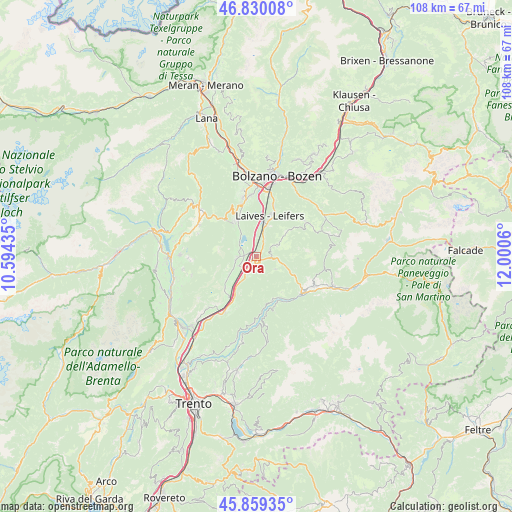
Ora GPS coordinates[2]
46° 20' 48.732" North, 11° 17' 50.892" East
| Map corner | latitude | longitude |
|---|---|---|
| Upper-left | 46.83008°, | 10.59435° |
| Center: | 46.34687°, | 11.29747° |
| Lower-right: | 45.85935°, | 12.0006° |
| Map W x H: | 107.9×107.9 km | = 67×67mi |
| max Lat: | 47.04031° ⇑2.7% North |
| Ora: | 46.34687° |
| min Lat: | ⇓97.3% South 35.50142° |
| min Long | Ora | max Long |
| 6.69888° | 11.29747° | 18.48682° |
| W 46.8%⇐ | ⇒53.2% E |
Elevation
Elevation of Ora is 249 m = 817 ft, and this is 57.7 m = 189 ft below average elevation for this country.
| Max E: |
2085 m = 6841 ft | 47.6% |
| Avg. | 306.7 m = 1006 ft | |
| Ora | 249 m = 817 ft | |
Min E: |
-4 m = -13 ft | 52.4% |
See also: Italy elevation on elevation.city.
Geographical zone
Ora is located in North temperate zone (between Tropic of Cancer and the Arctic Circle). Distance of this North polar circle is 2247.9 km =1396.8 mi to North.| Distance of | km | miles | from Ora |
|---|---|---|---|
| North Pole | 4853.8 | 3016 | to North |
| Arctic Circle | 2247.9 | 1396.8 | to North |
| Tropic Cancer | 2547.4 | 1582.9 | to South |
| Equator | 5153.3 | 3202.1 | to South |


Nearby cities:
15 places around Ora: (largest is in red/bold)
• Aldino
4.9 km =3 mi,  64°
64°
• Anterivo
9.3 km =5.8 mi,  145°
145°
• Bronzolo
6.5 km =4 mi,  15°
15°
• Caldaro sulla Strada del Vino
8.4 km =5.2 mi,  331°
331°
• Capriana
9.9 km =6.2 mi,  161°
161°
• Cortaccia sulla Strada del Vino
6.7 km =4.2 mi,  237°
237°
• Cortina sulla Strada del Vino
10.4 km =6.5 mi,  213°
213°
• Egna
3.7 km =2.3 mi, 209°
• Laghetti
9.2 km =5.7 mi, 208°
• Laives
9.4 km =5.8 mi, 19°
• Magrè sulla Strada del Vino
9.3 km =5.8 mi,  225°
225°
• Montagna
1.9 km =1.2 mi,  173°
173°
• Termeno
4.3 km =2.7 mi,  261°
261°
• Trodena
4.9 km =3 mi,  124°
124°
• Vadena
7.4 km =4.6 mi,  4°
4°
Sources, notices
• [Note1] Compared only with cities in Italy existing in our database
• [Src1] Map data: © OpenStreetMap contributors (CC-BY-SA)
• [Src2] Other city data from geonames.org with taken over terms of usage.
• [Src3] Geographical zone / Annual Mean Temperature by Robert A. Rohde @ Wikipedia
