Colmurano geodata
Colmurano (The Marches) is a seat of a third-order administrative division; located in Italy in Europe/Rome (GMT+2) time zone. With population of 579 people, there are 9190 cities with bigger population in this country. Compared to other cities in Italy, 62% of cities are located further ↑North; 72% of cities are located further ←West and 71.2% of cities have lower elevation than Colmurano. Note1


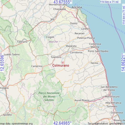
Colmurano GPS coordinates[2]
43° 9' 53.46" North, 13° 21' 32.688" East
| Map corner | latitude | longitude |
|---|---|---|
| Upper-left | 43.67555°, | 12.65596° |
| Center: | 43.16485°, | 13.35908° |
| Lower-right: | 42.64985°, | 14.06221° |
| Map W x H: | 114×114 km | = 70.8×70.8mi |
| max Lat: | 47.04031° ⇑62% North |
| Colmurano: | 43.16485° |
| min Lat: | ⇓38% South 35.50142° |
| min Long | Colmurano | max Long |
| 6.69888° | 13.35908° | 18.48682° |
| W 72%⇐ | ⇒28% E |
Elevation
Elevation of Colmurano is 406 m = 1332 ft, and this is 99.3 m = 326 ft above average elevation for this country.
| Max E: |
2085 m = 6841 ft | 28.8% |
| Colmurano | 406 m 1332 ft | |
| Avg. | 306.7 m = 1006 ft | |
Min E: |
-4 m = -13 ft | 71.2% |
See also: Italy elevation on elevation.city.
Geographical zone
Colmurano is located in North temperate zone (between Tropic of Cancer and the Arctic Circle). Distance of this Northern Tropic circle is 2193.6 km =1363 mi to South.| Distance of | km | miles | from Colmurano |
|---|---|---|---|
| North Pole | 5207.6 | 3235.9 | to North |
| Arctic Circle | 2601.7 | 1616.6 | to North |
| Tropic Cancer | 2193.6 | 1363 | to South |
| Equator | 4799.5 | 2982.3 | to South |


Nearby cities:
15 places around Colmurano: (largest is in red/bold)
• Belforte del Chienti
9.4 km =5.8 mi,  269°
269°
• Camporotondo di Fiastrone
8.4 km =5.2 mi,  244°
244°
• Casette Verdini
10.2 km =6.3 mi,  19°
19°
• Cessapalombo
10.4 km =6.5 mi,  232°
232°
• Loro Piceno
4.3 km =2.7 mi,  90°
90°
• Massa Fermana
9.7 km =6 mi,  101°
101°
• Mogliano
11 km =6.8 mi,  76°
76°
• Montappone
9.5 km =5.9 mi,  109°
109°
• Passo del Bidollo
10.7 km =6.6 mi,  29°
29°
• Petriolo
10.4 km =6.5 mi,  52°
52°
• Ripe San Ginesio
2.6 km =1.6 mi,  165°
165°
• San Ginesio
7.1 km =4.4 mi,  205°
205°
• Sant'Angelo in Pontano
8.1 km =5 mi,  157°
157°
• Tolentino
7.8 km =4.8 mi,  309°
309°
• Urbisaglia
3.4 km =2.1 mi, 22°
Sources, notices
• [Note1] Compared only with cities in Italy existing in our database
• [Src1] Map data: © OpenStreetMap contributors (CC-BY-SA)
• [Src2] Other city data from geonames.org with taken over terms of usage.
• [Src3] Geographical zone / Annual Mean Temperature by Robert A. Rohde @ Wikipedia
