Tolentino geodata
Tolentino (The Marches) is a seat of a third-order administrative division; located in Italy in Europe/Rome (GMT+2) time zone. With population of 16,504 people, there are 552 cities with bigger population in this country. Compared to other cities in Italy, 61.8% of cities are located further ↑North; 71.2% of cities are located further ←West and 50.6% of cities have higher elevation than Tolentino. Note1


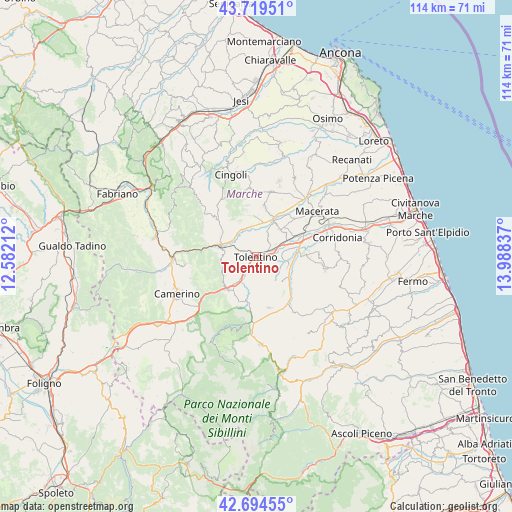
Tolentino GPS coordinates[2]
43° 12' 33.048" North, 13° 17' 6.864" East
| Map corner | latitude | longitude |
|---|---|---|
| Upper-left | 43.71951°, | 12.58212° |
| Center: | 43.20918°, | 13.28524° |
| Lower-right: | 42.69455°, | 13.98837° |
| Map W x H: | 114×114 km | = 70.8×70.8mi |
| max Lat: | 47.04031° ⇑61.8% North |
| Tolentino: | 43.20918° |
| min Lat: | ⇓38.2% South 35.50142° |
| min Long | Tolentino | max Long |
| 6.69888° | 13.28524° | 18.48682° |
| W 71.2%⇐ | ⇒28.8% E |
Elevation
Elevation of Tolentino is 231 m = 758 ft, and this is 75.7 m = 248 ft below average elevation for this country.
| Max E: |
2085 m = 6841 ft | 50.6% |
| Avg. | 306.7 m = 1006 ft | |
| Tolentino | 231 m = 758 ft | |
Min E: |
-4 m = -13 ft | 49.4% |
See also: Italy elevation on elevation.city.
Geographical zone
Tolentino is located in North temperate zone (between Tropic of Cancer and the Arctic Circle). Distance of this Northern Tropic circle is 2198.5 km =1366.1 mi to South.| Distance of | km | miles | from Tolentino |
|---|---|---|---|
| North Pole | 5202.7 | 3232.8 | to North |
| Arctic Circle | 2596.8 | 1613.6 | to North |
| Tropic Cancer | 2198.5 | 1366.1 | to South |
| Equator | 4804.4 | 2985.3 | to South |


Nearby cities:
15 places around Tolentino: (largest is in red/bold)
• Belforte del Chienti
6 km =3.7 mi,  214°
214°
• Caldarola
8.9 km =5.5 mi, 214°
• Camporotondo di Fiastrone
8.7 km =5.4 mi,  190°
190°
• Casette Verdini
10.5 km =6.5 mi,  63°
63°
• Cesolo
9.4 km =5.8 mi,  307°
307°
• Cessapalombo
11.4 km =7.1 mi, 191°
• Colmurano
7.8 km =4.8 mi,  129°
129°
• Loro Piceno
11.4 km =7.1 mi,  115°
115°
• Passo di Treia
9.4 km =5.8 mi,  23°
23°
• Pollenza
8.1 km =5 mi,  38°
38°
• Ripe San Ginesio
10 km =6.2 mi,  138°
138°
• San Severino Marche
8.9 km =5.5 mi,  285°
285°
• Serrapetrona
8.5 km =5.3 mi,  244°
244°
• Treia
11.2 km =7 mi,  10°
10°
• Urbisaglia
7.5 km =4.7 mi,  103°
103°
Sources, notices
• [Note1] Compared only with cities in Italy existing in our database
• [Src1] Map data: © OpenStreetMap contributors (CC-BY-SA)
• [Src2] Other city data from geonames.org with taken over terms of usage.
• [Src3] Geographical zone / Annual Mean Temperature by Robert A. Rohde @ Wikipedia
