Triora geodata
Triora (Liguria) is a seat of a third-order administrative division; located in Italy in Europe/Rome (GMT+2) time zone. With population of 272 people, there are 10795 cities with bigger population in this country. Compared to other cities in Italy, 54.7% of cities are located further ↑North; 95.9% of cities are located further →East and 91.8% of cities have lower elevation than Triora. Note1


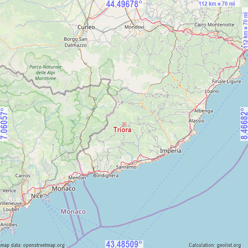
Triora GPS coordinates[2]
43° 59' 35.124" North, 7° 45' 49.284" East
| Map corner | latitude | longitude |
|---|---|---|
| Upper-left | 44.49678°, | 7.06057° |
| Center: | 43.99309°, | 7.76369° |
| Lower-right: | 43.48509°, | 8.46682° |
| Map W x H: | 112.5×112.5 km | = 69.9×69.9mi |
| max Lat: | 47.04031° ⇑54.7% North |
| Triora: | 43.99309° |
| min Lat: | ⇓45.3% South 35.50142° |
| min Long | Triora | max Long |
| 6.69888° | 7.76369° | 18.48682° |
| W 4.1%⇐ | ⇒95.9% E |
Elevation
Elevation of Triora is 765 m = 2510 ft, and this is 458.3 m = 1504 ft above average elevation for this country.
| Max E: |
2085 m = 6841 ft | 8.2% |
| Triora | 765 m 2510 ft | |
| Avg. | 306.7 m = 1006 ft | |
Min E: |
-4 m = -13 ft | 91.8% |
See also: Italy elevation on elevation.city.
Geographical zone
Triora is located in North temperate zone (between Tropic of Cancer and the Arctic Circle). Distance of this Northern Tropic circle is 2285.7 km =1420.3 mi to South.| Distance of | km | miles | from Triora |
|---|---|---|---|
| North Pole | 5115.5 | 3178.6 | to North |
| Arctic Circle | 2509.6 | 1559.4 | to North |
| Tropic Cancer | 2285.7 | 1420.3 | to South |
| Equator | 4891.6 | 3039.5 | to South |


Nearby cities:
15 places around Triora: (largest is in red/bold)
• Aurigo
12.8 km =8 mi,  95°
95°
• Badalucco
10.7 km =6.6 mi,  142°
142°
• Bajardo
10.4 km =6.5 mi,  197°
197°
• Briga Alta
10 km =6.2 mi,  353°
353°
• Carpasio
9 km =5.6 mi,  113°
113°
• Castel Vittorio
10.2 km =6.3 mi,  224°
224°
• Ceriana
12.5 km =7.8 mi,  175°
175°
• Cosio di Arroscia
10.9 km =6.8 mi,  30°
30°
• Mendatica
9.9 km =6.2 mi,  19°
19°
• Molini di Triora
1 km =0.6 mi,  117°
117°
• Montalto Ligure
9.7 km =6 mi, 137°
• Montegrosso Pian Latte
9.2 km =5.7 mi, 27°
• Pigna
10.6 km =6.6 mi,  230°
230°
• Pornassio
12.1 km =7.5 mi,  44°
44°
• Rezzo
9.2 km =5.7 mi,  70°
70°
Sources, notices
• [Note1] Compared only with cities in Italy existing in our database
• [Src1] Map data: © OpenStreetMap contributors (CC-BY-SA)
• [Src2] Other city data from geonames.org with taken over terms of usage.
• [Src3] Geographical zone / Annual Mean Temperature by Robert A. Rohde @ Wikipedia
