Badalucco geodata
Badalucco (Liguria) is a seat of a third-order administrative division; located in Italy in Europe/Rome (GMT+2) time zone. With population of 1,100 people, there are 6297 cities with bigger population in this country. Compared to other cities in Italy, 55.5% of cities are located further ↑North; 95.2% of cities are located further →East and 57.3% of cities have higher elevation than Badalucco. Note1


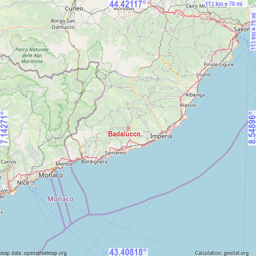
Badalucco GPS coordinates[2]
43° 55' 0.588" North, 7° 50' 45.024" East
| Map corner | latitude | longitude |
|---|---|---|
| Upper-left | 44.42117°, | 7.14271° |
| Center: | 43.91683°, | 7.84584° |
| Lower-right: | 43.40818°, | 8.54896° |
| Map W x H: | 112.6×112.6 km | = 70×70mi |
| max Lat: | 47.04031° ⇑55.5% North |
| Badalucco: | 43.91683° |
| min Lat: | ⇓44.5% South 35.50142° |
| min Long | Badalucco | max Long |
| 6.69888° | 7.84584° | 18.48682° |
| W 4.8%⇐ | ⇒95.2% E |
Elevation
Elevation of Badalucco is 185 m = 607 ft, and this is 121.7 m = 399 ft below average elevation for this country.
| Max E: |
2085 m = 6841 ft | 57.3% |
| Avg. | 306.7 m = 1006 ft | |
| Badalucco | 185 m = 607 ft | |
Min E: |
-4 m = -13 ft | 42.7% |
See also: Italy elevation on elevation.city.
Geographical zone
Badalucco is located in North temperate zone (between Tropic of Cancer and the Arctic Circle). Distance of this Northern Tropic circle is 2277.2 km =1415 mi to South.| Distance of | km | miles | from Badalucco |
|---|---|---|---|
| North Pole | 5124 | 3183.9 | to North |
| Arctic Circle | 2518.1 | 1564.7 | to North |
| Tropic Cancer | 2277.2 | 1415 | to South |
| Equator | 4883.1 | 3034.2 | to South |


Nearby cities:
15 places around Badalucco: (largest is in red/bold)
• Aurigo
9.6 km =6 mi,  40°
40°
• Carpasio
5.1 km =3.2 mi,  18°
18°
• Castellaro
6.1 km =3.8 mi,  162°
162°
• Ceriana
7 km =4.3 mi,  234°
234°
• Civezza
9.4 km =5.8 mi,  115°
115°
• Dolcedo
8.4 km =5.2 mi,  97°
97°
• Molini
7.5 km =4.7 mi,  82°
82°
• Montalto Ligure
1.3 km =0.8 mi,  356°
356°
• Pietrabruna
5.5 km =3.4 mi, 123°
• Pompeiana
7.9 km =4.9 mi,  154°
154°
• Prelà Castello
8.3 km =5.2 mi,  71°
71°
• Riva Ligure
9.1 km =5.7 mi, 162°
• Taggia
7.9 km =4.9 mi,  176°
176°
• Terzorio
8.3 km =5.2 mi, 149°
• Vasia
8.8 km =5.5 mi, 78°
Sources, notices
• [Note1] Compared only with cities in Italy existing in our database
• [Src1] Map data: © OpenStreetMap contributors (CC-BY-SA)
• [Src2] Other city data from geonames.org with taken over terms of usage.
• [Src3] Geographical zone / Annual Mean Temperature by Robert A. Rohde @ Wikipedia
