Aurigo geodata
Aurigo (Liguria) is a seat of a third-order administrative division; located in Italy in Europe/Rome (GMT+2) time zone. With population of 267 people, there are 10817 cities with bigger population in this country. Compared to other cities in Italy, 54.9% of cities are located further ↑North; 94.5% of cities are located further →East and 72.5% of cities have lower elevation than Aurigo. Note1


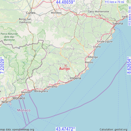
Aurigo GPS coordinates[2]
43° 58' 58.116" North, 7° 55' 24.312" East
| Map corner | latitude | longitude |
|---|---|---|
| Upper-left | 44.48659°, | 7.22029° |
| Center: | 43.98281°, | 7.92342° |
| Lower-right: | 43.47472°, | 8.62654° |
| Map W x H: | 112.5×112.5 km | = 69.9×69.9mi |
| max Lat: | 47.04031° ⇑54.9% North |
| Aurigo: | 43.98281° |
| min Lat: | ⇓45.1% South 35.50142° |
| min Long | Aurigo | max Long |
| 6.69888° | 7.92342° | 18.48682° |
| W 5.5%⇐ | ⇒94.5% E |
Elevation
Elevation of Aurigo is 420 m = 1378 ft, and this is 113.3 m = 372 ft above average elevation for this country.
| Max E: |
2085 m = 6841 ft | 27.5% |
| Aurigo | 420 m 1378 ft | |
| Avg. | 306.7 m = 1006 ft | |
Min E: |
-4 m = -13 ft | 72.5% |
See also: Italy elevation on elevation.city.
Geographical zone
Aurigo is located in North temperate zone (between Tropic of Cancer and the Arctic Circle). Distance of this Northern Tropic circle is 2284.5 km =1419.5 mi to South.| Distance of | km | miles | from Aurigo |
|---|---|---|---|
| North Pole | 5116.6 | 3179.3 | to North |
| Arctic Circle | 2510.7 | 1560.1 | to North |
| Tropic Cancer | 2284.5 | 1419.5 | to South |
| Equator | 4890.4 | 3038.8 | to South |


Nearby cities:
15 places around Aurigo: (largest is in red/bold)
• Borgomaro
1.9 km =1.2 mi,  116°
116°
• Caravonica
3 km =1.9 mi,  67°
67°
• Carpasio
5.2 km =3.2 mi,  241°
241°
• Cesio
5 km =3.1 mi,  55°
55°
• Chiusanico
5.6 km =3.5 mi,  101°
101°
• Chiusavecchia
5.2 km =3.2 mi,  109°
109°
• Dolcedo
8.6 km =5.3 mi,  166°
166°
• Lucinasco
3.5 km =2.2 mi, 122°
• Molini
6.4 km =4 mi, 169°
• Pieve di Teco
7.2 km =4.5 mi,  355°
355°
• Prelà Castello
5 km =3.1 mi,  160°
160°
• Rezzo
5.9 km =3.7 mi,  315°
315°
• Testico
8.6 km =5.3 mi, 72°
• Vasia
6.1 km =3.8 mi, 156°
• Vessalico
7.6 km =4.7 mi,  22°
22°
Sources, notices
• [Note1] Compared only with cities in Italy existing in our database
• [Src1] Map data: © OpenStreetMap contributors (CC-BY-SA)
• [Src2] Other city data from geonames.org with taken over terms of usage.
• [Src3] Geographical zone / Annual Mean Temperature by Robert A. Rohde @ Wikipedia
