Montegrosso Pian Latte geodata
Montegrosso Pian Latte (Liguria) is a seat of a third-order administrative division; located in Italy in Europe/Rome (GMT+2) time zone. With population of 140 people, there are 11313 cities with bigger population in this country. Compared to other cities in Italy, 54.1% of cities are located further ↑North; 95.5% of cities are located further →East and 91.1% of cities have lower elevation than Montegrosso Pian Latte. Note1
Administrative division(s):
- Level 1: Liguria
- Level 2: Provincia di Imperia
- Level 3: Montegrosso Pian Latte
Current local time in Montegrosso Pian Latte:
11:34 PM, WednesdayDifference from your time zone: hours


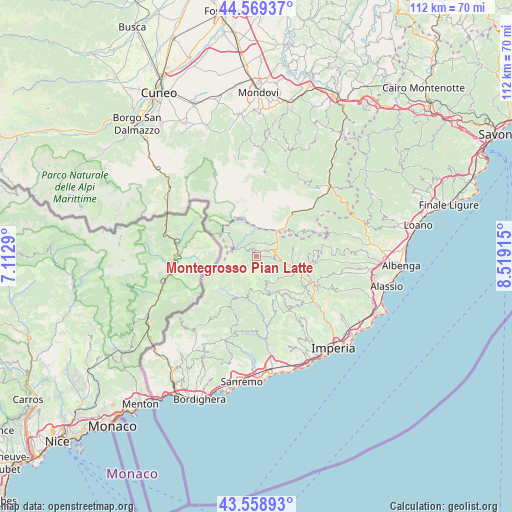
Montegrosso Pian Latte GPS coordinates[2]
44° 3' 58.716" North, 7° 48' 57.672" East
| Map corner | latitude | longitude |
|---|---|---|
| Upper-left | 44.56937°, | 7.1129° |
| Center: | 44.06631°, | 7.81602° |
| Lower-right: | 43.55893°, | 8.51915° |
| Map W x H: | 112.4×112.3 km | = 69.8×69.8mi |
| max Lat: | 47.04031° ⇑54.1% North |
| Montegrosso Pian Latte: | 44.06631° |
| min Lat: | ⇓45.9% South 35.50142° |
| min Long | Montegrosso Pia | max Long |
| 6.69888° | 7.81602° | 18.48682° |
| W 4.5%⇐ | ⇒95.5% E |
Elevation
Elevation of Montegrosso Pian Latte is 747 m = 2451 ft, and this is 440.3 m = 1445 ft above average elevation for this country.
| Max E: |
2085 m = 6841 ft | 8.9% |
| Montegrosso Pian Latte | 747 m 2451 ft | |
| Avg. | 306.7 m = 1006 ft | |
Min E: |
-4 m = -13 ft | 91.1% |
See also: Italy elevation on elevation.city.
Geographical zone
Montegrosso Pian Latte is located in North temperate zone (between Tropic of Cancer and the Arctic Circle). Distance of this Northern Tropic circle is 2293.8 km =1425.3 mi to South.| Distance of | km | miles | from Montegrosso Pian Latte |
|---|---|---|---|
| North Pole | 5107.3 | 3173.5 | to North |
| Arctic Circle | 2501.5 | 1554.4 | to North |
| Tropic Cancer | 2293.8 | 1425.3 | to South |
| Equator | 4899.7 | 3044.5 | to South |


Nearby cities:
15 places around Montegrosso Pian Latte: (largest is in red/bold)
• Armo
8.3 km =5.2 mi,  73°
73°
• Aurigo
12.6 km =7.8 mi,  137°
137°
• Borghetto d'Arroscia
13.2 km =8.2 mi,  94°
94°
• Briga Alta
5.6 km =3.5 mi,  288°
288°
• Caprauna
12.4 km =7.7 mi,  63°
63°
• Carpasio
12.5 km =7.8 mi,  161°
161°
• Cosio di Arroscia
1.8 km =1.1 mi,  46°
46°
• Mendatica
1.5 km =0.9 mi,  325°
325°
• Molini di Triora
9.2 km =5.7 mi,  201°
201°
• Ormea
13.4 km =8.3 mi,  41°
41°
• Pieve di Teco
8.2 km =5.1 mi,  105°
105°
• Pornassio
4.3 km =2.7 mi,  83°
83°
• Rezzo
6.7 km =4.2 mi, 138°
• Triora
9.2 km =5.7 mi,  207°
207°
• Vessalico
11.7 km =7.3 mi,  101°
101°
Sources, notices
• [Note1] Compared only with cities in Italy existing in our database
• [Src1] Map data: © OpenStreetMap contributors (CC-BY-SA)
• [Src2] Other city data from geonames.org with taken over terms of usage.
• [Src3] Geographical zone / Annual Mean Temperature by Robert A. Rohde @ Wikipedia
