Tresnuraghes geodata
Tresnuraghes (Sardinia) is a seat of a third-order administrative division; located in Italy in Europe/Rome (GMT+2) time zone. With population of 1,004 people, there are 6646 cities with bigger population in this country. Compared to other cities in Italy, 86% of cities are located further ↑North; 87.7% of cities are located further →East and 54.4% of cities have lower elevation than Tresnuraghes. Note1


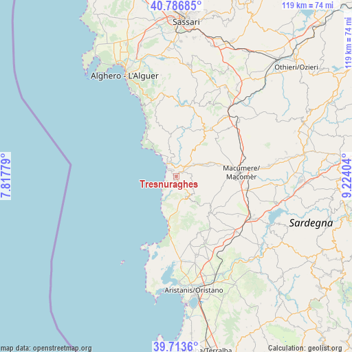
Tresnuraghes GPS coordinates[2]
40° 15' 8.46" North, 8° 31' 15.312" East
| Map corner | latitude | longitude |
|---|---|---|
| Upper-left | 40.78685°, | 7.81779° |
| Center: | 40.25235°, | 8.52092° |
| Lower-right: | 39.7136°, | 9.22404° |
| Map W x H: | 119.3×119.3 km | = 74.1×74.1mi |
| max Lat: | 47.04031° ⇑86% North |
| Tresnuraghes: | 40.25235° |
| min Lat: | ⇓14% South 35.50142° |
| min Long | Tresnuraghes | max Long |
| 6.69888° | 8.52092° | 18.48682° |
| W 12.3%⇐ | ⇒87.7% E |
Elevation
Elevation of Tresnuraghes is 262 m = 860 ft, and this is 44.7 m = 147 ft below average elevation for this country.
| Max E: |
2085 m = 6841 ft | 45.6% |
| Avg. | 306.7 m = 1006 ft | |
| Tresnuraghes | 262 m = 860 ft | |
Min E: |
-4 m = -13 ft | 54.4% |
See also: Italy elevation on elevation.city.
Geographical zone
Tresnuraghes is located in North temperate zone (between Tropic of Cancer and the Arctic Circle). Distance of this Northern Tropic circle is 1869.7 km =1161.8 mi to South.| Distance of | km | miles | from Tresnuraghes |
|---|---|---|---|
| North Pole | 5531.4 | 3437.1 | to North |
| Arctic Circle | 2925.5 | 1817.8 | to North |
| Tropic Cancer | 1869.7 | 1161.8 | to South |
| Equator | 4475.6 | 2781 | to South |


Nearby cities:
15 places around Tresnuraghes: (largest is in red/bold)
• Bosa
5.6 km =3.5 mi,  339°
339°
• Cuglieri
8.2 km =5.1 mi,  150°
150°
• Flussio
2.1 km =1.3 mi,  45°
45°
• Magomadas
1.2 km =0.7 mi,  9°
9°
• Modolo
2.7 km =1.7 mi,  16°
16°
• Montresta
13.6 km =8.5 mi,  352°
352°
• Padria
18.5 km =11.5 mi,  29°
29°
• Pozzomaggiore
20 km =12.4 mi,  35°
35°
• Sagama
4.9 km =3 mi,  77°
77°
• Santu Lussurgiu
16.8 km =10.4 mi,  137°
137°
• Scano di Montiferro
7 km =4.3 mi,  126°
126°
• Sennariolo
5.3 km =3.3 mi, 146°
• Sindia
12.5 km =7.8 mi,  67°
67°
• Suni
4 km =2.5 mi, 37°
• Tinnura
3 km =1.9 mi, 51°
Sources, notices
• [Note1] Compared only with cities in Italy existing in our database
• [Src1] Map data: © OpenStreetMap contributors (CC-BY-SA)
• [Src2] Other city data from geonames.org with taken over terms of usage.
• [Src3] Geographical zone / Annual Mean Temperature by Robert A. Rohde @ Wikipedia
