Torpè geodata
Torpè (Sardinia) is a seat of a third-order administrative division; located in Italy in Europe/Rome (GMT+2) time zone. With population of 2,044 people, there are 4081 cities with bigger population in this country. Compared to other cities in Italy, 83.3% of cities are located further ↑North; 71% of cities are located further →East and 91.1% of cities have higher elevation than Torpè. Note1


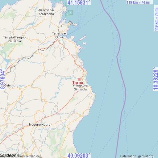
Torpè GPS coordinates[2]
40° 37' 40.08" North, 9° 40' 44.976" East
| Map corner | latitude | longitude |
|---|---|---|
| Upper-left | 41.15931°, | 8.97604° |
| Center: | 40.6278°, | 9.67916° |
| Lower-right: | 40.09203°, | 10.38229° |
| Map W x H: | 118.7×118.7 km | = 73.8×73.8mi |
| max Lat: | 47.04031° ⇑83.3% North |
| Torpè: | 40.6278° |
| min Lat: | ⇓16.7% South 35.50142° |
| min Long | Torpè | max Long |
| 6.69888° | 9.67916° | 18.48682° |
| W 29%⇐ | ⇒71% E |
Elevation
Elevation of Torpè is 16 m = 52 ft, and this is 290.7 m = 954 ft below average elevation for this country.
| Max E: |
2085 m = 6841 ft | 91.1% |
| Avg. | 306.7 m = 1006 ft | |
| Torpè | 16 m = 52 ft | |
Min E: |
-4 m = -13 ft | 8.9% |
See also: Italy elevation on elevation.city.
Geographical zone
Torpè is located in North temperate zone (between Tropic of Cancer and the Arctic Circle). Distance of this Northern Tropic circle is 1911.5 km =1187.8 mi to South.| Distance of | km | miles | from Torpè |
|---|---|---|---|
| North Pole | 5489.7 | 3411.1 | to North |
| Arctic Circle | 2883.8 | 1791.9 | to North |
| Tropic Cancer | 1911.5 | 1187.8 | to South |
| Equator | 4517.4 | 2807 | to South |


Nearby cities:
15 places around Torpè: (largest is in red/bold)
• Buddittogliu Straulas
13.1 km =8.1 mi,  348°
348°
• Budoni
8.8 km =5.5 mi,  13°
13°
• Galtellì
27.6 km =17.1 mi,  191°
191°
• Irgoli
24.6 km =15.3 mi, 189°
• La Caletta
6.4 km =4 mi,  108°
108°
• Loculi
25.2 km =15.7 mi, 193°
• Lodè
12.5 km =7.8 mi,  251°
251°
• Lula
23.9 km =14.9 mi,  222°
222°
• Onanì
25.5 km =15.8 mi,  231°
231°
• Onifai
24.7 km =15.3 mi, 185°
• Padru
20.4 km =12.7 mi,  319°
319°
• Posada
3.4 km =2.1 mi,  82°
82°
• San Teodoro
16.2 km =10.1 mi,  357°
357°
• Siniscola
6.2 km =3.9 mi,  166°
166°
• Tanaunella
7.4 km =4.6 mi,  31°
31°
Sources, notices
• [Note1] Compared only with cities in Italy existing in our database
• [Src1] Map data: © OpenStreetMap contributors (CC-BY-SA)
• [Src2] Other city data from geonames.org with taken over terms of usage.
• [Src3] Geographical zone / Annual Mean Temperature by Robert A. Rohde @ Wikipedia
