Posada geodata
Posada (Sardinia) is a seat of a third-order administrative division; located in Italy in Europe/Rome (GMT+2) time zone. With population of 2,025 people, there are 4113 cities with bigger population in this country. Compared to other cities in Italy, 83.2% of cities are located further ↑North; 70.6% of cities are located further →East and 96.6% of cities have higher elevation than Posada. Note1


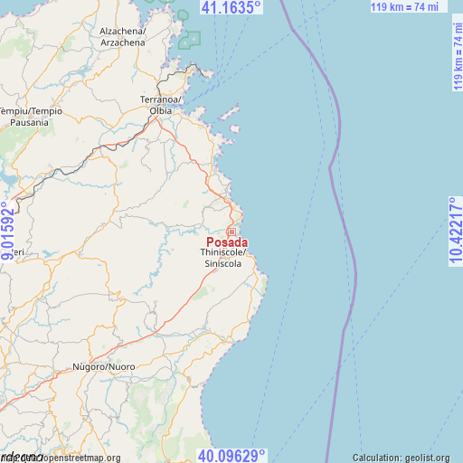
Posada GPS coordinates[2]
40° 37' 55.308" North, 9° 43' 8.544" East
| Map corner | latitude | longitude |
|---|---|---|
| Upper-left | 41.1635°, | 9.01592° |
| Center: | 40.63203°, | 9.71904° |
| Lower-right: | 40.09629°, | 10.42217° |
| Map W x H: | 118.7×118.7 km | = 73.8×73.8mi |
| max Lat: | 47.04031° ⇑83.2% North |
| Posada: | 40.63203° |
| min Lat: | ⇓16.8% South 35.50142° |
| min Long | Posada | max Long |
| 6.69888° | 9.71904° | 18.48682° |
| W 29.4%⇐ | ⇒70.6% E |
Elevation
Elevation of Posada is 6 m = 20 ft, and this is 300.7 m = 987 ft below average elevation for this country.
| Max E: |
2085 m = 6841 ft | 96.6% |
| Avg. | 306.7 m = 1006 ft | |
| Posada | 6 m = 20 ft | |
Min E: |
-4 m = -13 ft | 3.4% |
See also: Italy elevation on elevation.city.
Geographical zone
Posada is located in North temperate zone (between Tropic of Cancer and the Arctic Circle). Distance of this Northern Tropic circle is 1911.9 km =1188 mi to South.| Distance of | km | miles | from Posada |
|---|---|---|---|
| North Pole | 5489.2 | 3410.8 | to North |
| Arctic Circle | 2883.3 | 1791.6 | to North |
| Tropic Cancer | 1911.9 | 1188 | to South |
| Equator | 4517.9 | 2807.3 | to South |


Nearby cities:
15 places around Posada: (largest is in red/bold)
• Buddittogliu Straulas
13.7 km =8.5 mi,  333°
333°
• Budoni
8.2 km =5.1 mi,  350°
350°
• Irgoli
25.8 km =16 mi,  196°
196°
• La Caletta
3.6 km =2.2 mi,  132°
132°
• Loculi
26.7 km =16.6 mi, 200°
• Lodè
15.9 km =9.9 mi,  253°
253°
• Lula
26.6 km =16.5 mi,  227°
227°
• Onifai
25.7 km =16 mi,  193°
193°
• Orosei
28.3 km =17.6 mi,  184°
184°
• Padru
22.4 km =13.9 mi,  311°
311°
• Porto San Paolo
28.1 km =17.5 mi,  344°
344°
• San Teodoro
16.3 km =10.1 mi, 345°
• Siniscola
6.8 km =4.2 mi, 195°
• Tanaunella
5.8 km =3.6 mi,  5°
5°
• Torpè
3.4 km =2.1 mi,  262°
262°
Sources, notices
• [Note1] Compared only with cities in Italy existing in our database
• [Src1] Map data: © OpenStreetMap contributors (CC-BY-SA)
• [Src2] Other city data from geonames.org with taken over terms of usage.
• [Src3] Geographical zone / Annual Mean Temperature by Robert A. Rohde @ Wikipedia
