Ortona geodata
Ortona (Abruzzo) is a seat of a third-order administrative division; located in Italy in Europe/Rome (GMT+2) time zone. With population of 13,327 people, there are 688 cities with bigger population in this country. Compared to other cities in Italy, 67.2% of cities are located further ↑North; 81.8% of cities are located further ←West and 74.9% of cities have higher elevation than Ortona. Note1


Ortona GPS coordinates[2]
42° 21' 3.132" North, 14° 24' 12.312" East
| Map corner | latitude | longitude |
|---|---|---|
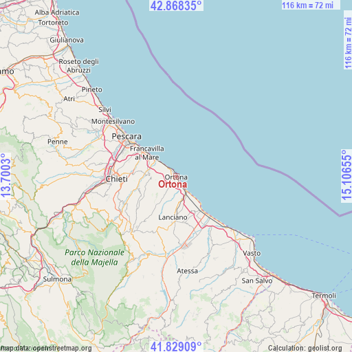
| Upper-left | 42.86835°, | 13.7003° |
| Center: | 42.35087°, | 14.40342° |
| Lower-right: | 41.82909°, | 15.10655° |
| Map W x H: | 115.6×115.6 km | = 71.8×71.8mi |
| max Lat: | 47.04031° ⇑67.2% North |
| Ortona: | 42.35087° |
| min Lat: | ⇓32.8% South 35.50142° |
| min Long | Ortona | max Long |
| 6.69888° | 14.40342° | 18.48682° |
| W 81.8%⇐ | ⇒18.2% E |
Elevation
Elevation of Ortona is 74 m = 243 ft, and this is 232.7 m = 763 ft below average elevation for this country.
| Max E: |
2085 m = 6841 ft | 74.9% |
| Avg. | 306.7 m = 1006 ft | |
| Ortona | 74 m = 243 ft | |
Min E: |
-4 m = -13 ft | 25.1% |
See also: Italy elevation on elevation.city.
Geographical zone
Ortona is located in North temperate zone (between Tropic of Cancer and the Arctic Circle). Distance of this Northern Tropic circle is 2103.1 km =1306.8 mi to South.| Distance of | km | miles | from Ortona |
|---|---|---|---|
| North Pole | 5298.1 | 3292.1 | to North |
| Arctic Circle | 2692.2 | 1672.9 | to North |
| Tropic Cancer | 2103.1 | 1306.8 | to South |
| Equator | 4709 | 2926 | to South |


Nearby cities:
15 places around Ortona: (largest is in red/bold)
• Canosa Sannita
10.1 km =6.3 mi,  233°
233°
• Crecchio
8.6 km =5.3 mi, 226°
• Frisa
9.7 km =6 mi,  193°
193°
• Giuliano Teatino
11 km =6.8 mi,  246°
246°
• Marina di San Vito
6.3 km =3.9 mi,  143°
143°
• Miglianico
9.2 km =5.7 mi,  274°
274°
• Rocca San Giovanni
12.6 km =7.8 mi,  157°
157°
• San Vito Chietino
7.5 km =4.7 mi,  154°
154°
• Sant'Apollinare
6.1 km =3.8 mi,  175°
175°
• Santa Lucia
2.1 km =1.3 mi, 178°
• Tollo
6.6 km =4.1 mi,  264°
264°
• Treglio
10 km =6.2 mi,  170°
170°
• Villa Caldari
7 km =4.3 mi,  209°
209°
• Villa Grande
4.1 km =2.5 mi, 232°
• Villa San Leonardo
4.5 km =2.8 mi, 183°
Sources, notices
• [Note1] Compared only with cities in Italy existing in our database
• [Src1] Map data: © OpenStreetMap contributors (CC-BY-SA)
• [Src2] Other city data from geonames.org with taken over terms of usage.
• [Src3] Geographical zone / Annual Mean Temperature by Robert A. Rohde @ Wikipedia
