Santo geodata
Santo (Veneto) is a populated place; located in Italy in Europe/Rome (GMT+2) time zone. With population of 571 people, there are 9253 cities with bigger population in this country. Compared to other cities in Italy, 80% of cities are located further ↓South; 50.7% of cities are located further →East and 70.4% of cities have higher elevation than Santo. Note1


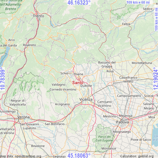
Santo GPS coordinates[2]
45° 40' 26.724" North, 11° 29' 13.596" East
| Map corner | latitude | longitude |
|---|---|---|
| Upper-left | 46.16323°, | 10.78399° |
| Center: | 45.67409°, | 11.48711° |
| Lower-right: | 45.18063°, | 12.19024° |
| Map W x H: | 109.3×109.3 km | = 67.9×67.9mi |
| max Lat: | 47.04031° ⇑20% North |
| Santo: | 45.67409° |
| min Lat: | ⇓80% South 35.50142° |
| min Long | Santo | max Long |
| 6.69888° | 11.48711° | 18.48682° |
| W 49.3%⇐ | ⇒50.7% E |
Elevation
Elevation of Santo is 95 m = 312 ft, and this is 211.7 m = 695 ft below average elevation for this country.
| Max E: |
2085 m = 6841 ft | 70.4% |
| Avg. | 306.7 m = 1006 ft | |
| Santo | 95 m = 312 ft | |
Min E: |
-4 m = -13 ft | 29.6% |
See also: Italy elevation on elevation.city.
Geographical zone
Santo is located in North temperate zone (between Tropic of Cancer and the Arctic Circle). Distance of this North polar circle is 2322.7 km =1443.3 mi to North.| Distance of | km | miles | from Santo |
|---|---|---|---|
| North Pole | 4928.6 | 3062.5 | to North |
| Arctic Circle | 2322.7 | 1443.3 | to North |
| Tropic Cancer | 2472.6 | 1536.4 | to South |
| Equator | 5078.5 | 3155.6 | to South |


Nearby cities:
15 places around Santo: (largest is in red/bold)
• Centrale
5.9 km =3.7 mi,  354°
354°
• Grumolo Pedemonte
5.6 km =3.5 mi,  4°
4°
• Isola Vicentina
5.9 km =3.7 mi,  212°
212°
• Levà
3.7 km =2.3 mi,  104°
104°
• Malo
5.8 km =3.6 mi,  253°
253°
• Marano Vicentino
4.9 km =3 mi,  299°
299°
• Mirabella
6.4 km =4 mi,  77°
77°
• Montecchio Precalcino
6 km =3.7 mi, 98°
• Novoledo
3.5 km =2.2 mi,  150°
150°
• Preara-Moraro-Levà Nord
4.4 km =2.7 mi, 81°
• Rozzampia
1.3 km =0.8 mi,  63°
63°
• Sarcedo
4.5 km =2.8 mi,  47°
47°
• Thiene
3.9 km =2.4 mi, 351°
• Villaverla
2.8 km =1.7 mi,  172°
172°
• Zanè
6.1 km =3.8 mi,  331°
331°
Sources, notices
• [Note1] Compared only with cities in Italy existing in our database
• [Src1] Map data: © OpenStreetMap contributors (CC-BY-SA)
• [Src2] Other city data from geonames.org with taken over terms of usage.
• [Src3] Geographical zone / Annual Mean Temperature by Robert A. Rohde @ Wikipedia
