Giavenale geodata
Giavenale (Veneto) is a populated place; located in Italy in Europe/Rome (GMT+2) time zone. With population of 1,014 people, there are 6608 cities with bigger population in this country. Compared to other cities in Italy, 81.2% of cities are located further ↓South; 51.9% of cities are located further →East and 60.9% of cities have higher elevation than Giavenale. Note1


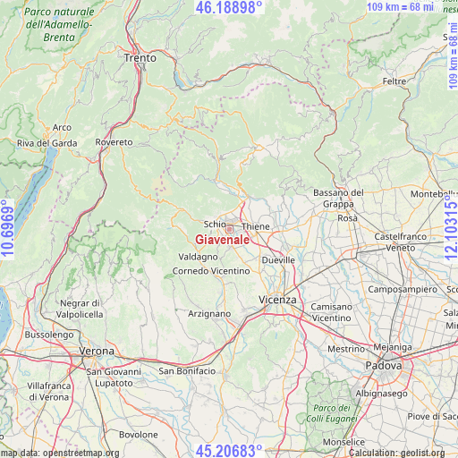
Giavenale GPS coordinates[2]
45° 42' 0.216" North, 11° 24' 0.072" East
| Map corner | latitude | longitude |
|---|---|---|
| Upper-left | 46.18898°, | 10.6969° |
| Center: | 45.70006°, | 11.40002° |
| Lower-right: | 45.20683°, | 12.10315° |
| Map W x H: | 109.2×109.2 km | = 67.9×67.9mi |
| max Lat: | 47.04031° ⇑18.8% North |
| Giavenale: | 45.70006° |
| min Lat: | ⇓81.2% South 35.50142° |
| min Long | Giavenale | max Long |
| 6.69888° | 11.40002° | 18.48682° |
| W 48.1%⇐ | ⇒51.9% E |
Elevation
Elevation of Giavenale is 156 m = 512 ft, and this is 150.7 m = 494 ft below average elevation for this country.
| Max E: |
2085 m = 6841 ft | 60.9% |
| Avg. | 306.7 m = 1006 ft | |
| Giavenale | 156 m = 512 ft | |
Min E: |
-4 m = -13 ft | 39.1% |
See also: Italy elevation on elevation.city.
Geographical zone
Giavenale is located in North temperate zone (between Tropic of Cancer and the Arctic Circle). Distance of this North polar circle is 2319.8 km =1441.5 mi to North.| Distance of | km | miles | from Giavenale |
|---|---|---|---|
| North Pole | 4925.7 | 3060.7 | to North |
| Arctic Circle | 2319.8 | 1441.5 | to North |
| Tropic Cancer | 2475.5 | 1538.2 | to South |
| Equator | 5081.4 | 3157.4 | to South |


Nearby cities:
15 places around Giavenale: (largest is in red/bold)
• Carrè
7 km =4.3 mi,  39°
39°
• Centrale
6.9 km =4.3 mi,  64°
64°
• Grumolo Pedemonte
7.7 km =4.8 mi,  69°
69°
• Malo
4.7 km =2.9 mi,  164°
164°
• Marano Vicentino
2.6 km =1.6 mi,  100°
100°
• Monte di Malo
5.4 km =3.4 mi,  214°
214°
• Piovene Rocchette
6.7 km =4.2 mi,  22°
22°
• San Vito di Leguzzano
1.9 km =1.2 mi, 207°
• Santo
7.4 km =4.6 mi,  113°
113°
• Santorso
3.9 km =2.4 mi,  345°
345°
• Schio
3.6 km =2.2 mi,  292°
292°
• Thiene
6.3 km =3.9 mi,  81°
81°
• Torrebelvicino
6.6 km =4.1 mi, 285°
• Zanè
4.5 km =2.8 mi, 57°
• Zona Industriale
2 km =1.2 mi,  12°
12°
Sources, notices
• [Note1] Compared only with cities in Italy existing in our database
• [Src1] Map data: © OpenStreetMap contributors (CC-BY-SA)
• [Src2] Other city data from geonames.org with taken over terms of usage.
• [Src3] Geographical zone / Annual Mean Temperature by Robert A. Rohde @ Wikipedia
