Levà geodata
Levà (Veneto) is a populated place; located in Italy in Europe/Rome (GMT+2) time zone. With population of 926 people, there are 7002 cities with bigger population in this country. Compared to other cities in Italy, 79.7% of cities are located further ↓South; 50.2% of cities are located further →East and 74% of cities have higher elevation than Levà. Note1
Administrative division(s):
- Level 1: Veneto
- Level 2: Provincia di Vicenza
- Level 3: Montecchio Precalcino


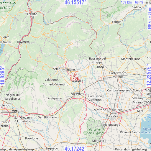
Levà GPS coordinates[2]
45° 39' 57.42" North, 11° 31' 57.432" East
| Map corner | latitude | longitude |
|---|---|---|
| Upper-left | 46.15517°, | 10.8295° |
| Center: | 45.66595°, | 11.53262° |
| Lower-right: | 45.17242°, | 12.23575° |
| Map W x H: | 109.3×109.3 km | = 67.9×67.9mi |
| max Lat: | 47.04031° ⇑20.3% North |
| Levà: | 45.66595° |
| min Lat: | ⇓79.7% South 35.50142° |
| min Long | Levà | max Long |
| 6.69888° | 11.53262° | 18.48682° |
| W 49.8%⇐ | ⇒50.2% E |
Elevation
Elevation of Levà is 78 m = 256 ft, and this is 228.7 m = 750 ft below average elevation for this country.
| Max E: |
2085 m = 6841 ft | 74% |
| Avg. | 306.7 m = 1006 ft | |
| Levà | 78 m = 256 ft | |
Min E: |
-4 m = -13 ft | 26% |
See also: Italy elevation on elevation.city.
Geographical zone
Levà is located in North temperate zone (between Tropic of Cancer and the Arctic Circle). Distance of this North polar circle is 2323.6 km =1443.8 mi to North.| Distance of | km | miles | from Levà |
|---|---|---|---|
| North Pole | 4929.5 | 3063 | to North |
| Arctic Circle | 2323.6 | 1443.8 | to North |
| Tropic Cancer | 2471.7 | 1535.8 | to South |
| Equator | 5077.6 | 3155.1 | to South |


Nearby cities:
15 places around Levà: (largest is in red/bold)
• Breganze
4.8 km =3 mi,  26°
26°
• Caldogno-Rettorgole-Cresole
6.9 km =4.3 mi,  199°
199°
• Dueville
3.7 km =2.3 mi,  156°
156°
• Maragnole
6 km =3.7 mi,  67°
67°
• Mirabella
3.6 km =2.2 mi,  50°
50°
• Montecchio Precalcino
2.4 km =1.5 mi,  90°
90°
• Novoledo
2.8 km =1.7 mi,  219°
219°
• Preara-Moraro-Levà Nord
1.7 km =1.1 mi, 27°
• Rozzampia
2.8 km =1.7 mi,  302°
302°
• Sandrigo
4.4 km =2.7 mi,  97°
97°
• Santo
3.7 km =2.3 mi,  284°
284°
• Sarcedo
3.9 km =2.4 mi,  356°
356°
• Thiene
6.3 km =3.9 mi,  319°
319°
• Villaverla
3.7 km =2.3 mi,  239°
239°
• Zugliano
7.1 km =4.4 mi,  354°
354°
Sources, notices
• [Note1] Compared only with cities in Italy existing in our database
• [Src1] Map data: © OpenStreetMap contributors (CC-BY-SA)
• [Src2] Other city data from geonames.org with taken over terms of usage.
• [Src3] Geographical zone / Annual Mean Temperature by Robert A. Rohde @ Wikipedia
