Gonzaga geodata
Gonzaga (Lombardy) is a seat of a third-order administrative division; located in Italy in Europe/Rome (GMT+2) time zone. With population of 5,230 people, there are 1871 cities with bigger population in this country. Compared to other cities in Italy, 58.9% of cities are located further ↓South; 59.5% of cities are located further →East and 89.6% of cities have higher elevation than Gonzaga. Note1


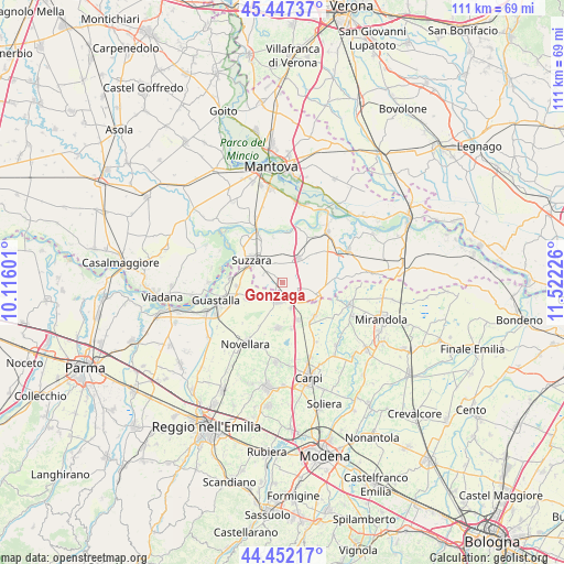
Gonzaga GPS coordinates[2]
44° 57' 6.948" North, 10° 49' 8.868" East
| Map corner | latitude | longitude |
|---|---|---|
| Upper-left | 45.44737°, | 10.11601° |
| Center: | 44.95193°, | 10.81913° |
| Lower-right: | 44.45217°, | 11.52226° |
| Map W x H: | 110.7×110.7 km | = 68.8×68.8mi |
| max Lat: | 47.04031° ⇑41.1% North |
| Gonzaga: | 44.95193° |
| min Lat: | ⇓58.9% South 35.50142° |
| min Long | Gonzaga | max Long |
| 6.69888° | 10.81913° | 18.48682° |
| W 40.5%⇐ | ⇒59.5% E |
Elevation
Elevation of Gonzaga is 19 m = 62 ft, and this is 287.7 m = 944 ft below average elevation for this country.
| Max E: |
2085 m = 6841 ft | 89.6% |
| Avg. | 306.7 m = 1006 ft | |
| Gonzaga | 19 m = 62 ft | |
Min E: |
-4 m = -13 ft | 10.4% |
See also: Italy elevation on elevation.city.
Geographical zone
Gonzaga is located in North temperate zone (between Tropic of Cancer and the Arctic Circle). Distance of this Northern Tropic circle is 2392.3 km =1486.5 mi to South.| Distance of | km | miles | from Gonzaga |
|---|---|---|---|
| North Pole | 5008.9 | 3112.4 | to North |
| Arctic Circle | 2403 | 1493.2 | to North |
| Tropic Cancer | 2392.3 | 1486.5 | to South |
| Equator | 4998.2 | 3105.7 | to South |


Nearby cities:
15 places around Gonzaga: (largest is in red/bold)
• Bondanello
10 km =6.2 mi,  85°
85°
• Bondeno
3.7 km =2.3 mi,  119°
119°
• Brugneto
5.6 km =3.5 mi,  233°
233°
• Codisotto
8 km =5 mi,  295°
295°
• Fabbrico
8.9 km =5.5 mi,  185°
185°
• Moglia
7.7 km =4.8 mi,  103°
103°
• Novi di Modena
9.4 km =5.8 mi,  137°
137°
• Palidano
3.8 km =2.4 mi,  305°
305°
• Pegognaga
5.7 km =3.5 mi,  33°
33°
• Polesine
3.9 km =2.4 mi,  342°
342°
• Reggiolo
3.8 km =2.4 mi, 190°
• Rolo
8.1 km =5 mi,  156°
156°
• Suzzara
7.4 km =4.6 mi, 307°
• Villa Saviola
8.8 km =5.5 mi,  350°
350°
• Villarotta
6.6 km =4.1 mi,  243°
243°
Sources, notices
• [Note1] Compared only with cities in Italy existing in our database
• [Src1] Map data: © OpenStreetMap contributors (CC-BY-SA)
• [Src2] Other city data from geonames.org with taken over terms of usage.
• [Src3] Geographical zone / Annual Mean Temperature by Robert A. Rohde @ Wikipedia
