Stagno Lombardo geodata
Stagno Lombardo (Lombardy) is a seat of a third-order administrative division; located in Italy in Europe/Rome (GMT+2) time zone. With population of 997 people, there are 6681 cities with bigger population in this country. Compared to other cities in Italy, 61.9% of cities are located further ↓South; 67% of cities are located further →East and 83.4% of cities have higher elevation than Stagno Lombardo. Note1
Administrative division(s):
- Level 1: Lombardy
- Level 2: Provincia di Cremona
- Level 3: Stagno Lombardo


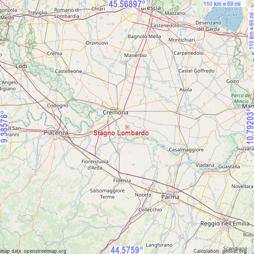
Stagno Lombardo GPS coordinates[2]
45° 4' 28.524" North, 10° 5' 20.04" East
| Map corner | latitude | longitude |
|---|---|---|
| Upper-left | 45.56897°, | 9.38578° |
| Center: | 45.07459°, | 10.0889° |
| Lower-right: | 44.5759°, | 10.79203° |
| Map W x H: | 110.4×110.4 km | = 68.6×68.6mi |
| max Lat: | 47.04031° ⇑38.1% North |
| Stagno Lombardo: | 45.07459° |
| min Lat: | ⇓61.9% South 35.50142° |
| min Long | Stagno Lombardo | max Long |
| 6.69888° | 10.0889° | 18.48682° |
| W 33%⇐ | ⇒67% E |
Elevation
Elevation of Stagno Lombardo is 36 m = 118 ft, and this is 270.7 m = 888 ft below average elevation for this country.
| Max E: |
2085 m = 6841 ft | 83.4% |
| Avg. | 306.7 m = 1006 ft | |
| Stagno Lombardo | 36 m = 118 ft | |
Min E: |
-4 m = -13 ft | 16.6% |
See also: Italy elevation on elevation.city.
Geographical zone
Stagno Lombardo is located in North temperate zone (between Tropic of Cancer and the Arctic Circle). Distance of this North polar circle is 2389.3 km =1484.6 mi to North.| Distance of | km | miles | from Stagno Lombardo |
|---|---|---|---|
| North Pole | 4995.2 | 3103.9 | to North |
| Arctic Circle | 2389.3 | 1484.6 | to North |
| Tropic Cancer | 2405.9 | 1495 | to South |
| Equator | 5011.8 | 3114.2 | to South |


Nearby cities:
15 places around Stagno Lombardo: (largest is in red/bold)
• Battaglione-Bagnara
4.9 km =3 mi,  339°
339°
• Bonemerse
4.4 km =2.7 mi,  348°
348°
• Bosco Ex Parmigiano
5.3 km =3.3 mi,  312°
312°
• Castelvetro Piacentino
8.3 km =5.2 mi,  291°
291°
• Cremona
8.4 km =5.2 mi,  320°
320°
• Gerre de' Caprioli
3.5 km =2.2 mi,  300°
300°
• Malagnino
7 km =4.3 mi,  16°
16°
• Pieve d'Olmi
3.2 km =2 mi,  58°
58°
• Pieveottoville
8.6 km =5.3 mi,  142°
142°
• Polesine Parmense
6.4 km =4 mi,  179°
179°
• San Daniele Po
6.9 km =4.3 mi,  96°
96°
• San Felice
7.7 km =4.8 mi, 351°
• San Giuliano
7.5 km =4.7 mi,  265°
265°
• Sospiro
6.6 km =4.1 mi, 56°
• Zibello
7 km =4.3 mi,  152°
152°
Sources, notices
• [Note1] Compared only with cities in Italy existing in our database
• [Src1] Map data: © OpenStreetMap contributors (CC-BY-SA)
• [Src2] Other city data from geonames.org with taken over terms of usage.
• [Src3] Geographical zone / Annual Mean Temperature by Robert A. Rohde @ Wikipedia
