Zibello geodata
Zibello (Emilia-Romagna) is a seat of a third-order administrative division; located in Italy in Europe/Rome (GMT+2) time zone. With population of 910 people, there are 7091 cities with bigger population in this country. Compared to other cities in Italy, 60.4% of cities are located further ↓South; 66.6% of cities are located further →East and 83.4% of cities have higher elevation than Zibello. Note1
Administrative division(s):
- Level 1: Emilia-Romagna
- Level 2: Provincia di Parma
- Level 3: Polesine Zibello


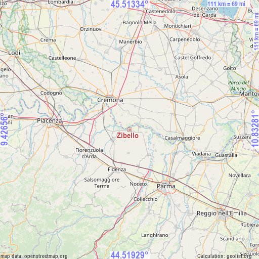
Zibello GPS coordinates[2]
45° 1' 6.492" North, 10° 7' 46.848" East
| Map corner | latitude | longitude |
|---|---|---|
| Upper-left | 45.51334°, | 9.42656° |
| Center: | 45.01847°, | 10.12968° |
| Lower-right: | 44.51929°, | 10.83281° |
| Map W x H: | 110.5×110.5 km | = 68.7×68.7mi |
| max Lat: | 47.04031° ⇑39.6% North |
| Zibello: | 45.01847° |
| min Lat: | ⇓60.4% South 35.50142° |
| min Long | Zibello | max Long |
| 6.69888° | 10.12968° | 18.48682° |
| W 33.4%⇐ | ⇒66.6% E |
Elevation
Elevation of Zibello is 36 m = 118 ft, and this is 270.7 m = 888 ft below average elevation for this country.
| Max E: |
2085 m = 6841 ft | 83.4% |
| Avg. | 306.7 m = 1006 ft | |
| Zibello | 36 m = 118 ft | |
Min E: |
-4 m = -13 ft | 16.6% |
See also: Italy elevation on elevation.city.
Geographical zone
Zibello is located in North temperate zone (between Tropic of Cancer and the Arctic Circle). Distance of this North polar circle is 2395.6 km =1488.6 mi to North.| Distance of | km | miles | from Zibello |
|---|---|---|---|
| North Pole | 5001.5 | 3107.8 | to North |
| Arctic Circle | 2395.6 | 1488.6 | to North |
| Tropic Cancer | 2399.7 | 1491.1 | to South |
| Equator | 5005.6 | 3110.3 | to South |


Nearby cities:
15 places around Zibello: (largest is in red/bold)
• Bonemerse
11.4 km =7.1 mi,  338°
338°
• Busseto
8.1 km =5 mi,  237°
237°
• Cella Dati
11.2 km =7 mi,  40°
40°
• Fontanelle
8.6 km =5.3 mi,  129°
129°
• Gerre de' Caprioli
10.1 km =6.3 mi,  322°
322°
• Motta Baluffi
10.9 km =6.8 mi,  67°
67°
• Pieve d'Olmi
7.9 km =4.9 mi,  356°
356°
• Pieveottoville
2.1 km =1.3 mi,  108°
108°
• Polesine Parmense
3.1 km =1.9 mi,  266°
266°
• Roccabianca
7.1 km =4.4 mi,  99°
99°
• San Daniele Po
6.5 km =4 mi,  34°
34°
• Soragna
10.2 km =6.3 mi,  184°
184°
• Sospiro
10.2 km =6.3 mi,  12°
12°
• Stagno Lombardo
7 km =4.3 mi,  332°
332°
• Villanova
10.3 km =6.4 mi, 274°
Sources, notices
• [Note1] Compared only with cities in Italy existing in our database
• [Src1] Map data: © OpenStreetMap contributors (CC-BY-SA)
• [Src2] Other city data from geonames.org with taken over terms of usage.
• [Src3] Geographical zone / Annual Mean Temperature by Robert A. Rohde @ Wikipedia
