Cremona geodata
Cremona (Lombardy) is a seat of a second-order administrative division; located in Italy in Europe/Rome (GMT+2) time zone. With population of 59,561 people, there are 86 cities with bigger population in this country. Compared to other cities in Italy, 63.3% of cities are located further ↓South; 67.6% of cities are located further →East and 79.6% of cities have higher elevation than Cremona. Note1


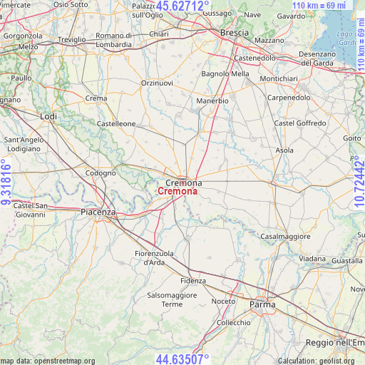
Cremona GPS coordinates[2]
45° 7' 59.7" North, 10° 1' 16.644" East
| Map corner | latitude | longitude |
|---|---|---|
| Upper-left | 45.62712°, | 9.31816° |
| Center: | 45.13325°, | 10.02129° |
| Lower-right: | 44.63507°, | 10.72442° |
| Map W x H: | 110.3×110.3 km | = 68.5×68.5mi |
| max Lat: | 47.04031° ⇑36.7% North |
| Cremona: | 45.13325° |
| min Lat: | ⇓63.3% South 35.50142° |
| min Long | Cremona | max Long |
| 6.69888° | 10.02129° | 18.48682° |
| W 32.4%⇐ | ⇒67.6% E |
Elevation
Elevation of Cremona is 52 m = 171 ft, and this is 254.7 m = 836 ft below average elevation for this country.
| Max E: |
2085 m = 6841 ft | 79.6% |
| Avg. | 306.7 m = 1006 ft | |
| Cremona | 52 m = 171 ft | |
Min E: |
-4 m = -13 ft | 20.4% |
See also: Cremona elevation on elevation.city.
Geographical zone
Cremona is located in North temperate zone (between Tropic of Cancer and the Arctic Circle). Distance of this North polar circle is 2382.8 km =1480.6 mi to North.| Distance of | km | miles | from Cremona |
|---|---|---|---|
| North Pole | 4988.7 | 3099.8 | to North |
| Arctic Circle | 2382.8 | 1480.6 | to North |
| Tropic Cancer | 2412.4 | 1499 | to South |
| Equator | 5018.3 | 3118.2 | to South |


Nearby cities:
15 places around Cremona: (largest is in red/bold)
• Ardole San Marino
7.1 km =4.4 mi,  68°
68°
• Battaglione-Bagnara
4.1 km =2.5 mi,  117°
117°
• Bonemerse
4.9 km =3 mi, 116°
• Boschetto
3.7 km =2.3 mi,  6°
6°
• Bosco Ex Parmigiano
3.2 km =2 mi,  154°
154°
• Casanova del Morbasco
5.6 km =3.5 mi,  305°
305°
• Castelverde
6.3 km =3.9 mi,  342°
342°
• Castelvetro Piacentino
4.2 km =2.6 mi,  215°
215°
• Costa Sant'Abramo
5.7 km =3.5 mi, 310°
• Gerre de' Caprioli
5.3 km =3.3 mi, 154°
• Malagnino
7.3 km =4.5 mi,  88°
88°
• Maristella
3.1 km =1.9 mi,  51°
51°
• Olza-Fogarole
5.5 km =3.4 mi,  237°
237°
• San Felice
4.3 km =2.7 mi,  75°
75°
• San Giuliano
7.4 km =4.6 mi,  196°
196°
Sources, notices
• [Note1] Compared only with cities in Italy existing in our database
• [Src1] Map data: © OpenStreetMap contributors (CC-BY-SA)
• [Src2] Other city data from geonames.org with taken over terms of usage.
• [Src3] Geographical zone / Annual Mean Temperature by Robert A. Rohde @ Wikipedia
