Bonemerse geodata
Bonemerse (Lombardy) is a seat of a third-order administrative division; located in Italy in Europe/Rome (GMT+2) time zone. With population of 1,282 people, there are 5691 cities with bigger population in this country. Compared to other cities in Italy, 62.8% of cities are located further ↓South; 67.1% of cities are located further →East and 82.2% of cities have higher elevation than Bonemerse. Note1


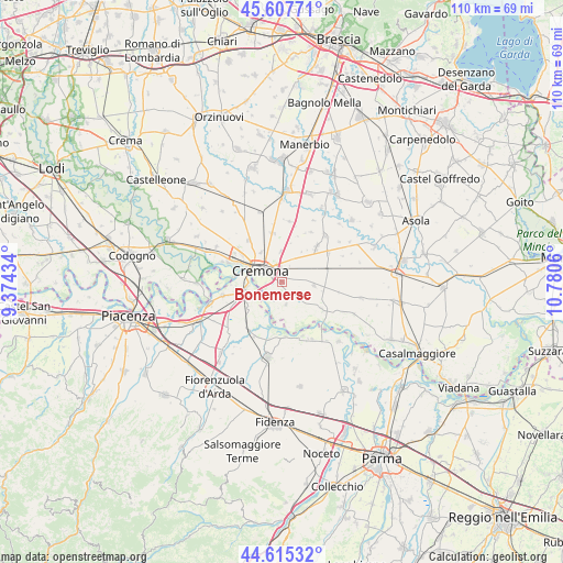
Bonemerse GPS coordinates[2]
45° 6' 49.212" North, 10° 4' 38.892" East
| Map corner | latitude | longitude |
|---|---|---|
| Upper-left | 45.60771°, | 9.37434° |
| Center: | 45.11367°, | 10.07747° |
| Lower-right: | 44.61532°, | 10.7806° |
| Map W x H: | 110.3×110.3 km | = 68.5×68.5mi |
| max Lat: | 47.04031° ⇑37.2% North |
| Bonemerse: | 45.11367° |
| min Lat: | ⇓62.8% South 35.50142° |
| min Long | Bonemerse | max Long |
| 6.69888° | 10.07747° | 18.48682° |
| W 32.9%⇐ | ⇒67.1% E |
Elevation
Elevation of Bonemerse is 41 m = 135 ft, and this is 265.7 m = 872 ft below average elevation for this country.
| Max E: |
2085 m = 6841 ft | 82.2% |
| Avg. | 306.7 m = 1006 ft | |
| Bonemerse | 41 m = 135 ft | |
Min E: |
-4 m = -13 ft | 17.8% |
See also: Italy elevation on elevation.city.
Geographical zone
Bonemerse is located in North temperate zone (between Tropic of Cancer and the Arctic Circle). Distance of this North polar circle is 2385 km =1482 mi to North.| Distance of | km | miles | from Bonemerse |
|---|---|---|---|
| North Pole | 4990.9 | 3101.2 | to North |
| Arctic Circle | 2385 | 1482 | to North |
| Tropic Cancer | 2410.3 | 1497.7 | to South |
| Equator | 5016.2 | 3116.9 | to South |


Nearby cities:
15 places around Bonemerse: (largest is in red/bold)
• Ardole San Marino
5.2 km =3.2 mi,  24°
24°
• Battaglione-Bagnara
0.9 km =0.6 mi,  290°
290°
• Boschetto
7 km =4.3 mi,  325°
325°
• Bosco Ex Parmigiano
3.1 km =1.9 mi,  256°
256°
• Castelvetro Piacentino
6.9 km =4.3 mi, 259°
• Cremona
4.9 km =3 mi,  296°
296°
• Dosimo
8.2 km =5.1 mi,  14°
14°
• Gadesco-Pieve Delmona
5.7 km =3.5 mi,  31°
31°
• Gerre de' Caprioli
3.3 km =2.1 mi,  218°
218°
• Malagnino
3.8 km =2.4 mi,  51°
51°
• Maristella
4.6 km =2.9 mi, 334°
• Pieve d'Olmi
4.5 km =2.8 mi,  126°
126°
• San Felice
3.3 km =2.1 mi,  354°
354°
• Sospiro
6.4 km =4 mi,  96°
96°
• Stagno Lombardo
4.4 km =2.7 mi,  168°
168°
Sources, notices
• [Note1] Compared only with cities in Italy existing in our database
• [Src1] Map data: © OpenStreetMap contributors (CC-BY-SA)
• [Src2] Other city data from geonames.org with taken over terms of usage.
• [Src3] Geographical zone / Annual Mean Temperature by Robert A. Rohde @ Wikipedia
