Il Romito geodata
Il Romito (Tuscany) is a populated place; located in Italy in Europe/Rome (GMT+2) time zone. With population of 1,197 people, there are 5970 cities with bigger population in this country. Compared to other cities in Italy, 58.6% of cities are located further ↑North; 61.4% of cities are located further →East and 87.8% of cities have higher elevation than Il Romito. Note1


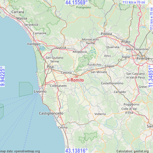
Il Romito GPS coordinates[2]
43° 38' 56.688" North, 10° 38' 43.368" East
| Map corner | latitude | longitude |
|---|---|---|
| Upper-left | 44.15569°, | 9.94225° |
| Center: | 43.64908°, | 10.64538° |
| Lower-right: | 43.13816°, | 11.34851° |
| Map W x H: | 113.1×113.1 km | = 70.3×70.3mi |
| max Lat: | 47.04031° ⇑58.6% North |
| Il Romito: | 43.64908° |
| min Lat: | ⇓41.4% South 35.50142° |
| min Long | Il Romito | max Long |
| 6.69888° | 10.64538° | 18.48682° |
| W 38.6%⇐ | ⇒61.4% E |
Elevation
Elevation of Il Romito is 23 m = 75 ft, and this is 283.7 m = 931 ft below average elevation for this country.
| Max E: |
2085 m = 6841 ft | 87.8% |
| Avg. | 306.7 m = 1006 ft | |
| Il Romito | 23 m = 75 ft | |
Min E: |
-4 m = -13 ft | 12.2% |
See also: Italy elevation on elevation.city.
Geographical zone
Il Romito is located in North temperate zone (between Tropic of Cancer and the Arctic Circle). Distance of this Northern Tropic circle is 2247.4 km =1396.5 mi to South.| Distance of | km | miles | from Il Romito |
|---|---|---|---|
| North Pole | 5153.7 | 3202.4 | to North |
| Arctic Circle | 2547.9 | 1583.2 | to North |
| Tropic Cancer | 2247.4 | 1396.5 | to South |
| Equator | 4853.3 | 3015.7 | to South |


Nearby cities:
15 places around Il Romito: (largest is in red/bold)
• Calcinaia
4.5 km =2.8 mi,  328°
328°
• Castel del Bosco
4.8 km =3 mi,  66°
66°
• Chiesino-Collodi
4.4 km =2.7 mi,  320°
320°
• Fornacette
5.4 km =3.4 mi,  295°
295°
• La Borra
1.5 km =0.9 mi,  241°
241°
• La Rotta
2.9 km =1.8 mi, 68°
• Lavaiano
5.4 km =3.4 mi,  246°
246°
• Montecalvoli
4.4 km =2.7 mi,  21°
21°
• Ponsacco
3.3 km =2.1 mi,  207°
207°
• Pontedera
1.8 km =1.1 mi, 319°
• Quattro Strade
6.8 km =4.2 mi,  8°
8°
• San Donato
4.7 km =2.9 mi,  49°
49°
• Santa Lucia
2.8 km =1.7 mi,  258°
258°
• Treggiaia
3.7 km =2.3 mi,  142°
142°
• Val di Cava
1.2 km =0.7 mi,  166°
166°
Sources, notices
• [Note1] Compared only with cities in Italy existing in our database
• [Src1] Map data: © OpenStreetMap contributors (CC-BY-SA)
• [Src2] Other city data from geonames.org with taken over terms of usage.
• [Src3] Geographical zone / Annual Mean Temperature by Robert A. Rohde @ Wikipedia
