Sommacampagna geodata
Sommacampagna (Veneto) is a seat of a third-order administrative division; located in Italy in Europe/Rome (GMT+2) time zone. With population of 7,258 people, there are 1341 cities with bigger population in this country. Compared to other cities in Italy, 70.4% of cities are located further ↓South; 59.2% of cities are located further →East and 70.4% of cities have higher elevation than Sommacampagna. Note1


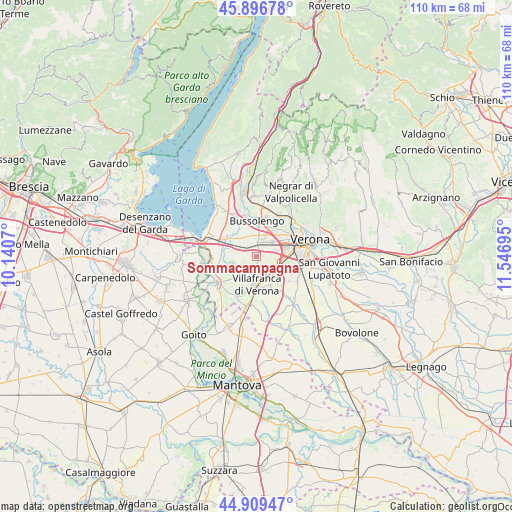
Sommacampagna GPS coordinates[2]
45° 24' 19.008" North, 10° 50' 37.752" East
| Map corner | latitude | longitude |
|---|---|---|
| Upper-left | 45.89678°, | 10.1407° |
| Center: | 45.40528°, | 10.84382° |
| Lower-right: | 44.90947°, | 11.54695° |
| Map W x H: | 109.8×109.8 km | = 68.2×68.2mi |
| max Lat: | 47.04031° ⇑29.6% North |
| Sommacampagna: | 45.40528° |
| min Lat: | ⇓70.4% South 35.50142° |
| min Long | Sommacampagna | max Long |
| 6.69888° | 10.84382° | 18.48682° |
| W 40.8%⇐ | ⇒59.2% E |
Elevation
Elevation of Sommacampagna is 95 m = 312 ft, and this is 211.7 m = 695 ft below average elevation for this country.
| Max E: |
2085 m = 6841 ft | 70.4% |
| Avg. | 306.7 m = 1006 ft | |
| Sommacampagna | 95 m = 312 ft | |
Min E: |
-4 m = -13 ft | 29.6% |
See also: Italy elevation on elevation.city.
Geographical zone
Sommacampagna is located in North temperate zone (between Tropic of Cancer and the Arctic Circle). Distance of this North polar circle is 2352.6 km =1461.8 mi to North.| Distance of | km | miles | from Sommacampagna |
|---|---|---|---|
| North Pole | 4958.5 | 3081.1 | to North |
| Arctic Circle | 2352.6 | 1461.8 | to North |
| Tropic Cancer | 2442.7 | 1517.8 | to South |
| Equator | 5048.6 | 3137.1 | to South |


Nearby cities:
15 places around Sommacampagna: (largest is in red/bold)
• Alpo
6.7 km =4.2 mi,  118°
118°
• Bassone
6.4 km =4 mi,  37°
37°
• Bussolengo
7.1 km =4.4 mi,  6°
6°
• Caluri
3.9 km =2.4 mi,  135°
135°
• Caselle
4.1 km =2.5 mi,  77°
77°
• Castelnuovo del Garda
7.5 km =4.7 mi,  299°
299°
• Custoza
4.8 km =3 mi,  229°
229°
• Dossobuono
5.4 km =3.4 mi,  104°
104°
• Lugagnano
4.4 km =2.7 mi,  45°
45°
• Madonna di Dossobuono
6.8 km =4.2 mi,  85°
85°
• Povegliano Veronese
7.1 km =4.4 mi,  156°
156°
• Rosegaferro
7.4 km =4.6 mi,  201°
201°
• San Giorgio in Salici
4.9 km =3 mi, 299°
• Sona
3.1 km =1.9 mi,  354°
354°
• Villafranca di Verona
5.7 km =3.5 mi,  179°
179°
Sources, notices
• [Note1] Compared only with cities in Italy existing in our database
• [Src1] Map data: © OpenStreetMap contributors (CC-BY-SA)
• [Src2] Other city data from geonames.org with taken over terms of usage.
• [Src3] Geographical zone / Annual Mean Temperature by Robert A. Rohde @ Wikipedia
