Caluri geodata
Caluri (Veneto) is a populated place; located in Italy in Europe/Rome (GMT+2) time zone. With population of 693 people, there are 8345 cities with bigger population in this country. Compared to other cities in Italy, 69.7% of cities are located further ↓South; 58.8% of cities are located further →East and 78.1% of cities have higher elevation than Caluri. Note1
Administrative division(s):
- Level 1: Veneto
- Level 2: Provincia di Verona
- Level 3: Villafranca di Verona


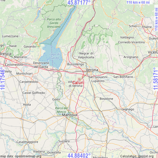
Caluri GPS coordinates[2]
45° 22' 48.18" North, 10° 52' 42.888" East
| Map corner | latitude | longitude |
|---|---|---|
| Upper-left | 45.87177°, | 10.17546° |
| Center: | 45.38005°, | 10.87858° |
| Lower-right: | 44.88402°, | 11.58171° |
| Map W x H: | 109.8×109.8 km | = 68.2×68.2mi |
| max Lat: | 47.04031° ⇑30.3% North |
| Caluri: | 45.38005° |
| min Lat: | ⇓69.7% South 35.50142° |
| min Long | Caluri | max Long |
| 6.69888° | 10.87858° | 18.48682° |
| W 41.2%⇐ | ⇒58.8% E |
Elevation
Elevation of Caluri is 59 m = 194 ft, and this is 247.7 m = 813 ft below average elevation for this country.
| Max E: |
2085 m = 6841 ft | 78.1% |
| Avg. | 306.7 m = 1006 ft | |
| Caluri | 59 m = 194 ft | |
Min E: |
-4 m = -13 ft | 21.9% |
See also: Italy elevation on elevation.city.
Geographical zone
Caluri is located in North temperate zone (between Tropic of Cancer and the Arctic Circle). Distance of this North polar circle is 2355.4 km =1463.6 mi to North.| Distance of | km | miles | from Caluri |
|---|---|---|---|
| North Pole | 4961.3 | 3082.8 | to North |
| Arctic Circle | 2355.4 | 1463.6 | to North |
| Tropic Cancer | 2439.9 | 1516.1 | to South |
| Equator | 5045.8 | 3135.3 | to South |


Nearby cities:
15 places around Caluri: (largest is in red/bold)
• Alpo
3.2 km =2 mi,  96°
96°
• Beccacivetta-Azzano
6.5 km =4 mi, 95°
• Caselle
3.9 km =2.4 mi,  19°
19°
• Custoza
6.4 km =4 mi,  267°
267°
• Dossobuono
2.9 km =1.8 mi,  59°
59°
• Forette
6.7 km =4.2 mi,  129°
129°
• Isolalta
5.9 km =3.7 mi,  144°
144°
• Lugagnano
5.9 km =3.7 mi,  4°
4°
• Madonna di Dossobuono
5.2 km =3.2 mi,  50°
50°
• Pizzoletta
6.8 km =4.2 mi,  211°
211°
• Povegliano Veronese
3.6 km =2.2 mi,  177°
177°
• Rosegaferro
6.8 km =4.2 mi,  233°
233°
• Sommacampagna
3.9 km =2.4 mi,  315°
315°
• Sona
6.6 km =4.1 mi,  332°
332°
• Villafranca di Verona
3.9 km =2.4 mi,  222°
222°
Sources, notices
• [Note1] Compared only with cities in Italy existing in our database
• [Src1] Map data: © OpenStreetMap contributors (CC-BY-SA)
• [Src2] Other city data from geonames.org with taken over terms of usage.
• [Src3] Geographical zone / Annual Mean Temperature by Robert A. Rohde @ Wikipedia
