Bussolengo geodata
Bussolengo (Veneto) is a seat of a third-order administrative division; located in Italy in Europe/Rome (GMT+2) time zone. With population of 15,170 people, there are 595 cities with bigger population in this country. Compared to other cities in Italy, 72.5% of cities are located further ↓South; 59.1% of cities are located further →East and 66.2% of cities have higher elevation than Bussolengo. Note1


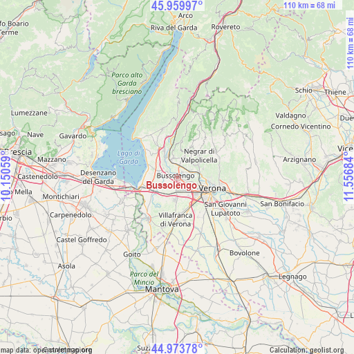
Bussolengo GPS coordinates[2]
45° 28' 8.508" North, 10° 51' 13.356" East
| Map corner | latitude | longitude |
|---|---|---|
| Upper-left | 45.95997°, | 10.15059° |
| Center: | 45.46903°, | 10.85371° |
| Lower-right: | 44.97378°, | 11.55684° |
| Map W x H: | 109.7×109.7 km | = 68.2×68.2mi |
| max Lat: | 47.04031° ⇑27.5% North |
| Bussolengo: | 45.46903° |
| min Lat: | ⇓72.5% South 35.50142° |
| min Long | Bussolengo | max Long |
| 6.69888° | 10.85371° | 18.48682° |
| W 40.9%⇐ | ⇒59.1% E |
Elevation
Elevation of Bussolengo is 120 m = 394 ft, and this is 186.7 m = 613 ft below average elevation for this country.
| Max E: |
2085 m = 6841 ft | 66.2% |
| Avg. | 306.7 m = 1006 ft | |
| Bussolengo | 120 m = 394 ft | |
Min E: |
-4 m = -13 ft | 33.8% |
See also: Italy elevation on elevation.city.
Geographical zone
Bussolengo is located in North temperate zone (between Tropic of Cancer and the Arctic Circle). Distance of this North polar circle is 2345.5 km =1457.4 mi to North.| Distance of | km | miles | from Bussolengo |
|---|---|---|---|
| North Pole | 4951.4 | 3076.7 | to North |
| Arctic Circle | 2345.5 | 1457.4 | to North |
| Tropic Cancer | 2449.8 | 1522.2 | to South |
| Equator | 5055.7 | 3141.5 | to South |


Nearby cities:
15 places around Bussolengo: (largest is in red/bold)
• Bassone
3.8 km =2.4 mi,  122°
122°
• Corrubbio
4.4 km =2.7 mi,  63°
63°
• Lugagnano
4.6 km =2.9 mi,  149°
149°
• Ospedaletto
4.1 km =2.5 mi,  347°
347°
• Pastrengo
5.2 km =3.2 mi,  304°
304°
• Pedemonte
6.3 km =3.9 mi,  53°
53°
• Pescantina
2.1 km =1.3 mi,  31°
31°
• San Pietro in Cariano
6 km =3.7 mi, 25°
• San Vito al Mantico
3 km =1.9 mi,  84°
84°
• Sandrà
5.3 km =3.3 mi,  259°
259°
• Sant'Ambrogio di Valpollicella
5.9 km =3.7 mi, 346°
• Santa Lucia
4.3 km =2.7 mi,  326°
326°
• Settimo
4.5 km =2.8 mi, 75°
• Sona
4.2 km =2.6 mi,  194°
194°
• Via Pastrengo
2.1 km =1.3 mi,  292°
292°
Sources, notices
• [Note1] Compared only with cities in Italy existing in our database
• [Src1] Map data: © OpenStreetMap contributors (CC-BY-SA)
• [Src2] Other city data from geonames.org with taken over terms of usage.
• [Src3] Geographical zone / Annual Mean Temperature by Robert A. Rohde @ Wikipedia
