Alessandria geodata
Alessandria (Piedmont) is a seat of a second-order administrative division; located in Italy in Europe/Rome (GMT+2) time zone. With population of 64,178 people, there are 80 cities with bigger population in this country. Compared to other cities in Italy, 58.1% of cities are located further ↓South; 86.6% of cities are located further →East and 69.6% of cities have higher elevation than Alessandria. Note1
Administrative division(s):
- Level 1: Piedmont
- Level 2: Provincia di Alessandria
- Level 3: Alessandria


Alessandria GPS coordinates[2]
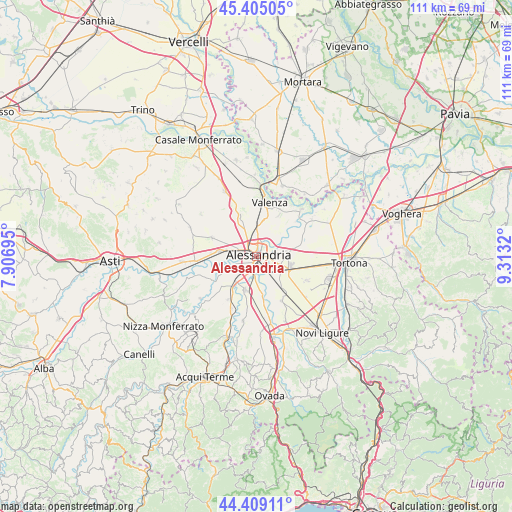
44° 54' 33.264" North, 8° 36' 36.252" East
| Map corner | latitude | longitude |
|---|---|---|
| Upper-left | 45.40505°, | 7.90695° |
| Center: | 44.90924°, | 8.61007° |
| Lower-right: | 44.40911°, | 9.3132° |
| Map W x H: | 110.7×110.7 km | = 68.8×68.8mi |
| max Lat: | 47.04031° ⇑41.9% North |
| Alessandria: | 44.90924° |
| min Lat: | ⇓58.1% South 35.50142° |
| min Long | Alessandria | max Long |
| 6.69888° | 8.61007° | 18.48682° |
| W 13.4%⇐ | ⇒86.6% E |
Elevation
Elevation of Alessandria is 100 m = 328 ft, and this is 206.7 m = 678 ft below average elevation for this country.
| Max E: |
2085 m = 6841 ft | 69.6% |
| Avg. | 306.7 m = 1006 ft | |
| Alessandria | 100 m = 328 ft | |
Min E: |
-4 m = -13 ft | 30.4% |
See also: Alessandria elevation on elevation.city.
Geographical zone
Alessandria is located in North temperate zone (between Tropic of Cancer and the Arctic Circle). Distance of this Northern Tropic circle is 2387.5 km =1483.5 mi to South.| Distance of | km | miles | from Alessandria |
|---|---|---|---|
| North Pole | 5013.6 | 3115.3 | to North |
| Arctic Circle | 2407.7 | 1496.1 | to North |
| Tropic Cancer | 2387.5 | 1483.5 | to South |
| Equator | 4993.4 | 3102.8 | to South |


Nearby cities:
15 places around Alessandria: (largest is in red/bold)
• Cabanette
3.9 km =2.4 mi,  220°
220°
• Cantalupo
6.5 km =4 mi, 223°
• Casal Cermelli
8.3 km =5.2 mi,  171°
171°
• Casalbagliano
3.6 km =2.2 mi,  248°
248°
• Castelceriolo
6.7 km =4.2 mi,  82°
82°
• Castellazzo Bormida
7.7 km =4.8 mi,  198°
198°
• Castelletto Monferrato
8.8 km =5.5 mi,  335°
335°
• Lobbi
8.8 km =5.5 mi, 75°
• Montecastello
7.4 km =4.6 mi,  53°
53°
• Pietra Marazzi
5.9 km =3.7 mi, 51°
• San Michele
3.2 km =2 mi,  311°
311°
• Solero
8.1 km =5 mi,  277°
277°
• Spinetta Marengo
5.9 km =3.7 mi,  116°
116°
• Valle San Bartolomeo
5.1 km =3.2 mi,  27°
27°
• Valmadonna
7.3 km =4.5 mi,  0°
0°
Sources, notices
• [Note1] Compared only with cities in Italy existing in our database
• [Src1] Map data: © OpenStreetMap contributors (CC-BY-SA)
• [Src2] Other city data from geonames.org with taken over terms of usage.
• [Src3] Geographical zone / Annual Mean Temperature by Robert A. Rohde @ Wikipedia
