Zeccone geodata
Zeccone (Lombardy) is a seat of a third-order administrative division; located in Italy in Europe/Rome (GMT+2) time zone. With population of 1,568 people, there are 4968 cities with bigger population in this country. Compared to other cities in Italy, 66.4% of cities are located further ↓South; 78% of cities are located further →East and 72.8% of cities have higher elevation than Zeccone. Note1


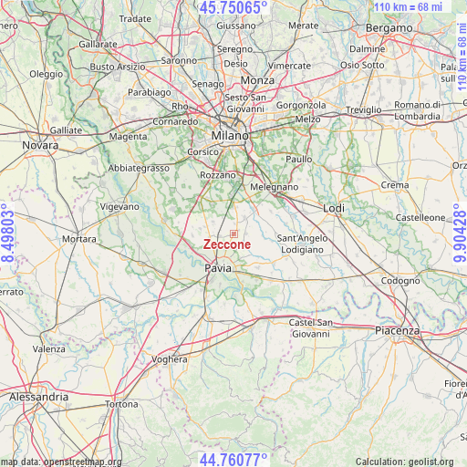
Zeccone GPS coordinates[2]
45° 15' 28.332" North, 9° 12' 4.14" East
| Map corner | latitude | longitude |
|---|---|---|
| Upper-left | 45.75065°, | 8.49803° |
| Center: | 45.25787°, | 9.20115° |
| Lower-right: | 44.76077°, | 9.90428° |
| Map W x H: | 110.1×110.1 km | = 68.4×68.4mi |
| max Lat: | 47.04031° ⇑33.6% North |
| Zeccone: | 45.25787° |
| min Lat: | ⇓66.4% South 35.50142° |
| min Long | Zeccone | max Long |
| 6.69888° | 9.20115° | 18.48682° |
| W 22%⇐ | ⇒78% E |
Elevation
Elevation of Zeccone is 84 m = 276 ft, and this is 222.7 m = 731 ft below average elevation for this country.
| Max E: |
2085 m = 6841 ft | 72.8% |
| Avg. | 306.7 m = 1006 ft | |
| Zeccone | 84 m = 276 ft | |
Min E: |
-4 m = -13 ft | 27.2% |
See also: Italy elevation on elevation.city.
Geographical zone
Zeccone is located in North temperate zone (between Tropic of Cancer and the Arctic Circle). Distance of this North polar circle is 2369 km =1472 mi to North.| Distance of | km | miles | from Zeccone |
|---|---|---|---|
| North Pole | 4974.9 | 3091.3 | to North |
| Arctic Circle | 2369 | 1472 | to North |
| Tropic Cancer | 2426.3 | 1507.6 | to South |
| Equator | 5032.2 | 3126.9 | to South |


Nearby cities:
15 places around Zeccone: (largest is in red/bold)
• Borgarello
5.1 km =3.2 mi,  248°
248°
• Bornasco
1.6 km =1 mi,  53°
53°
• Ceranova
3.3 km =2.1 mi,  85°
85°
• Certosa di Pavia
5.4 km =3.4 mi,  265°
265°
• Giussago
5.6 km =3.5 mi,  301°
301°
• Gualdrasco
2.5 km =1.6 mi,  5°
5°
• Guinzano
3.3 km =2.1 mi, 267°
• Lardirago
3.5 km =2.2 mi,  134°
134°
• San Genesio ed Uniti
3.1 km =1.9 mi,  212°
212°
• Sant'Alessio Con Vialone
4.4 km =2.7 mi,  153°
153°
• Torre del Mangano
5.6 km =3.5 mi,  263°
263°
• Torriano
6.4 km =4 mi, 273°
• Turago Bordone
4.7 km =2.9 mi,  326°
326°
• Vidigulfo
4.7 km =2.9 mi,  34°
34°
• Zibido al Lambro
6.2 km =3.9 mi,  67°
67°
Sources, notices
• [Note1] Compared only with cities in Italy existing in our database
• [Src1] Map data: © OpenStreetMap contributors (CC-BY-SA)
• [Src2] Other city data from geonames.org with taken over terms of usage.
• [Src3] Geographical zone / Annual Mean Temperature by Robert A. Rohde @ Wikipedia
