Casali-San Potito geodata
Casali-San Potito (Campania) is a populated place; located in Italy in Europe/Rome (GMT+2) time zone. With population of 2,761 people, there are 3254 cities with bigger population in this country. Compared to other cities in Italy, 81.7% of cities are located further ↑North; 84.3% of cities are located further ←West and 74.5% of cities have higher elevation than Casali-San Potito. Note1


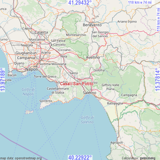
Casali-San Potito GPS coordinates[2]
40° 45' 50.04" North, 14° 40' 30.036" East
| Map corner | latitude | longitude |
|---|---|---|
| Upper-left | 41.29432°, | 13.97189° |
| Center: | 40.7639°, | 14.67501° |
| Lower-right: | 40.22922°, | 15.37814° |
| Map W x H: | 118.4×118.4 km | = 73.6×73.6mi |
| max Lat: | 47.04031° ⇑81.7% North |
| Casali-San Potito: | 40.7639° |
| min Lat: | ⇓18.3% South 35.50142° |
| min Long | Casali-San Poti | max Long |
| 6.69888° | 14.67501° | 18.48682° |
| W 84.3%⇐ | ⇒15.7% E |
Elevation
Elevation of Casali-San Potito is 76 m = 249 ft, and this is 230.7 m = 757 ft below average elevation for this country.
| Max E: |
2085 m = 6841 ft | 74.5% |
| Avg. | 306.7 m = 1006 ft | |
| Casali-San Potito | 76 m = 249 ft | |
Min E: |
-4 m = -13 ft | 25.5% |
See also: Italy elevation on elevation.city.
Geographical zone
Casali-San Potito is located in North temperate zone (between Tropic of Cancer and the Arctic Circle). Distance of this Northern Tropic circle is 1926.6 km =1197.1 mi to South.| Distance of | km | miles | from Casali-San Potito |
|---|---|---|---|
| North Pole | 5474.5 | 3401.7 | to North |
| Arctic Circle | 2868.7 | 1782.5 | to North |
| Tropic Cancer | 1926.6 | 1197.1 | to South |
| Equator | 4532.5 | 2816.4 | to South |


Nearby cities:
15 places around Casali-San Potito: (largest is in red/bold)
• Acquarola
4.3 km =2.7 mi,  82°
82°
• Bracigliano
6.7 km =4.2 mi,  24°
24°
• Carifi-Torello-Priscoli
5.7 km =3.5 mi,  57°
57°
• Castel San Giorgio
3 km =1.9 mi,  47°
47°
• Ciorani
6.6 km =4.1 mi, 46°
• Lanzara
1.2 km =0.7 mi,  4°
4°
• Nocera Inferiore
3.2 km =2 mi,  230°
230°
• Nocera Superiore
2.4 km =1.5 mi,  181°
181°
• Pagani
5.7 km =3.5 mi,  244°
244°
• Piazza del Galdo-Sant'Angelo
3.7 km =2.3 mi,  72°
72°
• Roccapiemonte
1.4 km =0.9 mi,  107°
107°
• Sant'Anna I
4.6 km =2.9 mi,  138°
138°
• Sarno
6.6 km =4.1 mi,  317°
317°
• Siano
4.5 km =2.8 mi, 19°
• Spiano
6.3 km =3.9 mi,  92°
92°
Sources, notices
• [Note1] Compared only with cities in Italy existing in our database
• [Src1] Map data: © OpenStreetMap contributors (CC-BY-SA)
• [Src2] Other city data from geonames.org with taken over terms of usage.
• [Src3] Geographical zone / Annual Mean Temperature by Robert A. Rohde @ Wikipedia
