Lanzara geodata
Lanzara (Campania) is a populated place; located in Italy in Europe/Rome (GMT+2) time zone. With population of 5,673 people, there are 1733 cities with bigger population in this country. Compared to other cities in Italy, 81.7% of cities are located further ↑North; 84.3% of cities are located further ←West and 74.9% of cities have higher elevation than Lanzara. Note1
Administrative division(s):
- Level 1: Campania
- Level 2: Provincia di Salerno
- Level 3: Castel San Giorgio


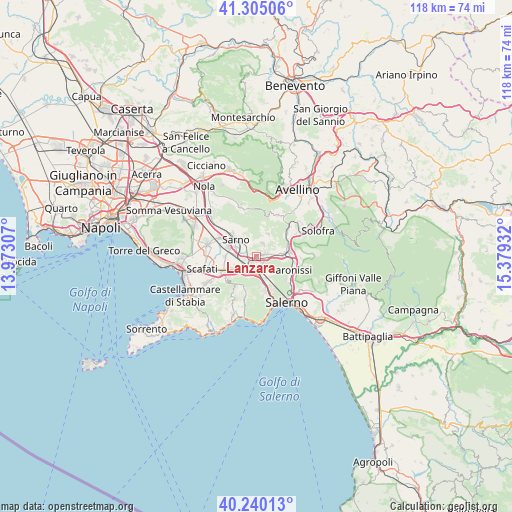
Lanzara GPS coordinates[2]
40° 46' 29.028" North, 14° 40' 34.284" East
| Map corner | latitude | longitude |
|---|---|---|
| Upper-left | 41.30506°, | 13.97307° |
| Center: | 40.77473°, | 14.67619° |
| Lower-right: | 40.24013°, | 15.37932° |
| Map W x H: | 118.4×118.4 km | = 73.6×73.6mi |
| max Lat: | 47.04031° ⇑81.7% North |
| Lanzara: | 40.77473° |
| min Lat: | ⇓18.3% South 35.50142° |
| min Long | Lanzara | max Long |
| 6.69888° | 14.67619° | 18.48682° |
| W 84.3%⇐ | ⇒15.7% E |
Elevation
Elevation of Lanzara is 74 m = 243 ft, and this is 232.7 m = 763 ft below average elevation for this country.
| Max E: |
2085 m = 6841 ft | 74.9% |
| Avg. | 306.7 m = 1006 ft | |
| Lanzara | 74 m = 243 ft | |
Min E: |
-4 m = -13 ft | 25.1% |
See also: Italy elevation on elevation.city.
Geographical zone
Lanzara is located in North temperate zone (between Tropic of Cancer and the Arctic Circle). Distance of this Northern Tropic circle is 1927.8 km =1197.9 mi to South.| Distance of | km | miles | from Lanzara |
|---|---|---|---|
| North Pole | 5473.3 | 3400.9 | to North |
| Arctic Circle | 2867.4 | 1781.7 | to North |
| Tropic Cancer | 1927.8 | 1197.9 | to South |
| Equator | 4533.7 | 2817.1 | to South |


Nearby cities:
15 places around Lanzara: (largest is in red/bold)
• Acquarola
4.2 km =2.6 mi,  99°
99°
• Bracigliano
5.6 km =3.5 mi,  28°
28°
• Carifi-Torello-Priscoli
5.1 km =3.2 mi,  68°
68°
• Casali-San Potito
1.2 km =0.7 mi,  184°
184°
• Castel San Giorgio
2.2 km =1.4 mi, 68°
• Ciorani
5.8 km =3.6 mi,  54°
54°
• Nocera Inferiore
4.2 km =2.6 mi,  218°
218°
• Nocera Superiore
3.6 km =2.2 mi, 182°
• Pagani
6.3 km =3.9 mi,  234°
234°
• Piazza del Galdo-Sant'Angelo
3.4 km =2.1 mi,  91°
91°
• Roccapiemonte
2 km =1.2 mi,  142°
142°
• Sant'Anna I
5.5 km =3.4 mi,  147°
147°
• Sarno
5.9 km =3.7 mi,  308°
308°
• Siano
3.4 km =2.1 mi, 25°
• Spiano
6.4 km =4 mi, 103°
Sources, notices
• [Note1] Compared only with cities in Italy existing in our database
• [Src1] Map data: © OpenStreetMap contributors (CC-BY-SA)
• [Src2] Other city data from geonames.org with taken over terms of usage.
• [Src3] Geographical zone / Annual Mean Temperature by Robert A. Rohde @ Wikipedia
