Serle geodata
Serle (Lombardy) is a seat of a third-order administrative division; located in Italy in Europe/Rome (GMT+2) time zone. With population of 2,154 people, there are 3926 cities with bigger population in this country. Compared to other cities in Italy, 75.6% of cities are located further ↓South; 64.3% of cities are located further →East and 78.1% of cities have lower elevation than Serle. Note1


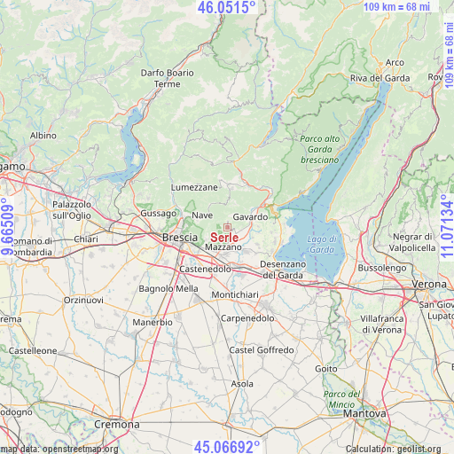
Serle GPS coordinates[2]
45° 33' 40.932" North, 10° 22' 5.556" East
| Map corner | latitude | longitude |
|---|---|---|
| Upper-left | 46.0515°, | 9.66509° |
| Center: | 45.56137°, | 10.36821° |
| Lower-right: | 45.06692°, | 11.07134° |
| Map W x H: | 109.5×109.5 km | = 68×68mi |
| max Lat: | 47.04031° ⇑24.4% North |
| Serle: | 45.56137° |
| min Lat: | ⇓75.6% South 35.50142° |
| min Long | Serle | max Long |
| 6.69888° | 10.36821° | 18.48682° |
| W 35.7%⇐ | ⇒64.3% E |
Elevation
Elevation of Serle is 494 m = 1621 ft, and this is 187.3 m = 615 ft above average elevation for this country.
| Max E: |
2085 m = 6841 ft | 21.9% |
| Serle | 494 m 1621 ft | |
| Avg. | 306.7 m = 1006 ft | |
Min E: |
-4 m = -13 ft | 78.1% |
See also: Italy elevation on elevation.city.
Geographical zone
Serle is located in North temperate zone (between Tropic of Cancer and the Arctic Circle). Distance of this North polar circle is 2335.2 km =1451 mi to North.| Distance of | km | miles | from Serle |
|---|---|---|---|
| North Pole | 4941.1 | 3070.3 | to North |
| Arctic Circle | 2335.2 | 1451 | to North |
| Tropic Cancer | 2460 | 1528.6 | to South |
| Equator | 5065.9 | 3147.8 | to South |


Nearby cities:
15 places around Serle: (largest is in red/bold)
• Bedizzole
7.1 km =4.4 mi,  142°
142°
• Botticino
5.7 km =3.5 mi,  231°
231°
• Caino
6.8 km =4.2 mi,  321°
321°
• Calvagese della Riviera
6.5 km =4 mi,  112°
112°
• Case Nuove
5.8 km =3.6 mi,  20°
20°
• Gavardo-Sopraponte
6.6 km =4.1 mi,  61°
61°
• Mazzano
4.7 km =2.9 mi,  193°
193°
• Nuvolento
2.3 km =1.4 mi, 137°
• Nuvolera
3.2 km =2 mi,  178°
178°
• Paitone
2.8 km =1.7 mi, 111°
• Patuzza
5.5 km =3.4 mi,  171°
171°
• Prevalle
4.3 km =2.7 mi,  104°
104°
• Rezzato
6.8 km =4.2 mi,  215°
215°
• San Gallo
4.7 km =2.9 mi,  271°
271°
• Vallio Terme
5.8 km =3.6 mi, 22°
Sources, notices
• [Note1] Compared only with cities in Italy existing in our database
• [Src1] Map data: © OpenStreetMap contributors (CC-BY-SA)
• [Src2] Other city data from geonames.org with taken over terms of usage.
• [Src3] Geographical zone / Annual Mean Temperature by Robert A. Rohde @ Wikipedia
