Sequals geodata
Sequals (Friuli Venezia Giulia) is a seat of a third-order administrative division; located in Italy in Europe/Rome (GMT+2) time zone. With population of 859 people, there are 7362 cities with bigger population in this country. Compared to other cities in Italy, 95.4% of cities are located further ↓South; 66.4% of cities are located further ←West and 53.9% of cities have higher elevation than Sequals. Note1
Administrative division(s):
- Level 1: Friuli Venezia Giulia
- Level 2: Provincia di Pordenone
- Level 3: Sequals


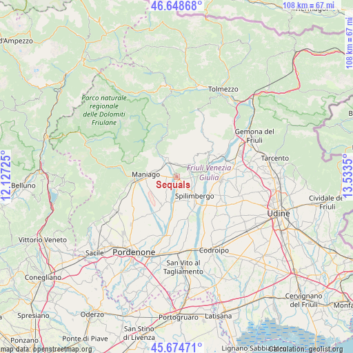
Sequals GPS coordinates[2]
46° 9' 49.86" North, 12° 49' 49.332" East
| Map corner | latitude | longitude |
|---|---|---|
| Upper-left | 46.64868°, | 12.12725° |
| Center: | 46.16385°, | 12.83037° |
| Lower-right: | 45.67471°, | 13.5335° |
| Map W x H: | 108.3×108.3 km | = 67.3×67.3mi |
| max Lat: | 47.04031° ⇑4.6% North |
| Sequals: | 46.16385° |
| min Lat: | ⇓95.4% South 35.50142° |
| min Long | Sequals | max Long |
| 6.69888° | 12.83037° | 18.48682° |
| W 66.4%⇐ | ⇒33.6% E |
Elevation
Elevation of Sequals is 210 m = 689 ft, and this is 96.7 m = 317 ft below average elevation for this country.
| Max E: |
2085 m = 6841 ft | 53.9% |
| Avg. | 306.7 m = 1006 ft | |
| Sequals | 210 m = 689 ft | |
Min E: |
-4 m = -13 ft | 46.1% |
See also: Italy elevation on elevation.city.
Geographical zone
Sequals is located in North temperate zone (between Tropic of Cancer and the Arctic Circle). Distance of this North polar circle is 2268.2 km =1409.4 mi to North.| Distance of | km | miles | from Sequals |
|---|---|---|---|
| North Pole | 4874.1 | 3028.6 | to North |
| Arctic Circle | 2268.2 | 1409.4 | to North |
| Tropic Cancer | 2527 | 1570.2 | to South |
| Equator | 5132.9 | 3189.4 | to South |


Nearby cities:
15 places around Sequals: (largest is in red/bold)
• Arba
3.7 km =2.3 mi,  237°
237°
• Barbeano
9 km =5.6 mi,  160°
160°
• Campagna
7.1 km =4.4 mi,  253°
253°
• Cavasso Nuovo
5.6 km =3.5 mi,  307°
307°
• Fanna
6.5 km =4 mi,  290°
290°
• Frisanco
9.7 km =6 mi,  303°
303°
• Lestans
4.5 km =2.8 mi,  98°
98°
• Maniago
9.6 km =6 mi,  271°
271°
• Meduno
6.2 km =3.9 mi,  337°
337°
• Paludea
6.9 km =4.3 mi,  54°
54°
• Pinzano al Tagliamento
9 km =5.6 mi,  76°
76°
• Spilimbergo
7.4 km =4.6 mi,  139°
139°
• Travesio
4.6 km =2.9 mi,  37°
37°
• Usago
4.2 km =2.6 mi,  58°
58°
• Valeriano
7 km =4.3 mi,  87°
87°
Sources, notices
• [Note1] Compared only with cities in Italy existing in our database
• [Src1] Map data: © OpenStreetMap contributors (CC-BY-SA)
• [Src2] Other city data from geonames.org with taken over terms of usage.
• [Src3] Geographical zone / Annual Mean Temperature by Robert A. Rohde @ Wikipedia
