Valeriano geodata
Valeriano (Friuli Venezia Giulia) is a populated place; located in Italy in Europe/Rome (GMT+2) time zone. With population of 619 people, there are 8850 cities with bigger population in this country. Compared to other cities in Italy, 95.5% of cities are located further ↓South; 67.4% of cities are located further ←West and 57.9% of cities have higher elevation than Valeriano. Note1
Administrative division(s):
- Level 1: Friuli Venezia Giulia
- Level 2: Provincia di Pordenone
- Level 3: Pinzano al Tagliamento


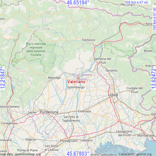
Valeriano GPS coordinates[2]
46° 10' 1.704" North, 12° 55' 17.724" East
| Map corner | latitude | longitude |
|---|---|---|
| Upper-left | 46.65194°, | 12.21847° |
| Center: | 46.16714°, | 12.92159° |
| Lower-right: | 45.67803°, | 13.62472° |
| Map W x H: | 108.3×108.3 km | = 67.3×67.3mi |
| max Lat: | 47.04031° ⇑4.5% North |
| Valeriano: | 46.16714° |
| min Lat: | ⇓95.5% South 35.50142° |
| min Long | Valeriano | max Long |
| 6.69888° | 12.92159° | 18.48682° |
| W 67.4%⇐ | ⇒32.6% E |
Elevation
Elevation of Valeriano is 180 m = 591 ft, and this is 126.7 m = 416 ft below average elevation for this country.
| Max E: |
2085 m = 6841 ft | 57.9% |
| Avg. | 306.7 m = 1006 ft | |
| Valeriano | 180 m = 591 ft | |
Min E: |
-4 m = -13 ft | 42.1% |
See also: Italy elevation on elevation.city.
Geographical zone
Valeriano is located in North temperate zone (between Tropic of Cancer and the Arctic Circle). Distance of this North polar circle is 2267.9 km =1409.2 mi to North.| Distance of | km | miles | from Valeriano |
|---|---|---|---|
| North Pole | 4873.8 | 3028.4 | to North |
| Arctic Circle | 2267.9 | 1409.2 | to North |
| Tropic Cancer | 2527.4 | 1570.5 | to South |
| Equator | 5133.3 | 3189.7 | to South |


Nearby cities:
15 places around Valeriano: (largest is in red/bold)
• Anduins
7.9 km =4.9 mi,  21°
21°
• Carpacco
6.1 km =3.8 mi,  151°
151°
• Clauzetto
6.9 km =4.3 mi,  356°
356°
• Forgaria nel Friuli
7.2 km =4.5 mi,  34°
34°
• Lestans
2.7 km =1.7 mi,  247°
247°
• Muris
6.1 km =3.8 mi,  67°
67°
• Paludea
3.9 km =2.4 mi,  338°
338°
• Pinzano al Tagliamento
2.4 km =1.5 mi,  46°
46°
• San Daniele del Friuli
6.7 km =4.2 mi,  99°
99°
• San Giacomo
4.8 km =3 mi,  82°
82°
• Sequals
7 km =4.3 mi,  267°
267°
• Spilimbergo
6.4 km =4 mi,  200°
200°
• Travesio
5.3 km =3.3 mi,  308°
308°
• Usago
3.9 km =2.4 mi,  298°
298°
• Villanova
5.4 km =3.4 mi,  135°
135°
Sources, notices
• [Note1] Compared only with cities in Italy existing in our database
• [Src1] Map data: © OpenStreetMap contributors (CC-BY-SA)
• [Src2] Other city data from geonames.org with taken over terms of usage.
• [Src3] Geographical zone / Annual Mean Temperature by Robert A. Rohde @ Wikipedia
