Spilimbergo geodata
Spilimbergo (Friuli Venezia Giulia) is a seat of a third-order administrative division; located in Italy in Europe/Rome (GMT+2) time zone. With population of 9,422 people, there are 997 cities with bigger population in this country. Compared to other cities in Italy, 94.2% of cities are located further ↓South; 67.2% of cities are located further ←West and 64.3% of cities have higher elevation than Spilimbergo. Note1
Administrative division(s):
- Level 1: Friuli Venezia Giulia
- Level 2: Provincia di Pordenone
- Level 3: Spilimbergo


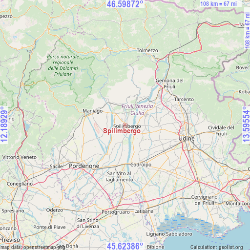
Spilimbergo GPS coordinates[2]
46° 6' 48.42" North, 12° 53' 32.676" East
| Map corner | latitude | longitude |
|---|---|---|
| Upper-left | 46.59872°, | 12.18929° |
| Center: | 46.11345°, | 12.89241° |
| Lower-right: | 45.62386°, | 13.59554° |
| Map W x H: | 108.4×108.4 km | = 67.4×67.4mi |
| max Lat: | 47.04031° ⇑5.8% North |
| Spilimbergo: | 46.11345° |
| min Lat: | ⇓94.2% South 35.50142° |
| min Long | Spilimbergo | max Long |
| 6.69888° | 12.89241° | 18.48682° |
| W 67.2%⇐ | ⇒32.8% E |
Elevation
Elevation of Spilimbergo is 132 m = 433 ft, and this is 174.7 m = 573 ft below average elevation for this country.
| Max E: |
2085 m = 6841 ft | 64.3% |
| Avg. | 306.7 m = 1006 ft | |
| Spilimbergo | 132 m = 433 ft | |
Min E: |
-4 m = -13 ft | 35.7% |
See also: Italy elevation on elevation.city.
Geographical zone
Spilimbergo is located in North temperate zone (between Tropic of Cancer and the Arctic Circle). Distance of this North polar circle is 2273.8 km =1412.9 mi to North.| Distance of | km | miles | from Spilimbergo |
|---|---|---|---|
| North Pole | 4879.7 | 3032.1 | to North |
| Arctic Circle | 2273.8 | 1412.9 | to North |
| Tropic Cancer | 2521.4 | 1566.7 | to South |
| Equator | 5127.3 | 3186 | to South |


Nearby cities:
15 places around Spilimbergo: (largest is in red/bold)
• Arba
8.7 km =5.4 mi,  294°
294°
• Barbeano
3.4 km =2.1 mi,  211°
211°
• Carpacco
5.2 km =3.2 mi,  83°
83°
• Cisterna
8 km =5 mi,  112°
112°
• Dignano
4.9 km =3 mi,  131°
131°
• Flaibano
9.4 km =5.8 mi, 130°
• Lestans
5 km =3.1 mi,  356°
356°
• Pinzano al Tagliamento
8.6 km =5.3 mi,  27°
27°
• Provesano
5.2 km =3.2 mi,  186°
186°
• Rodeano
9.2 km =5.7 mi,  91°
91°
• San Giorgio della Richinvelda
7.5 km =4.7 mi, 194°
• Sequals
7.4 km =4.6 mi,  319°
319°
• Usago
7.9 km =4.9 mi,  351°
351°
• Valeriano
6.4 km =4 mi,  20°
20°
• Villanova
6.4 km =4 mi,  70°
70°
Sources, notices
• [Note1] Compared only with cities in Italy existing in our database
• [Src1] Map data: © OpenStreetMap contributors (CC-BY-SA)
• [Src2] Other city data from geonames.org with taken over terms of usage.
• [Src3] Geographical zone / Annual Mean Temperature by Robert A. Rohde @ Wikipedia
