Sellano geodata
Sellano (Umbria) is a seat of a third-order administrative division; located in Italy in Europe/Rome (GMT+2) time zone. With population of 247 people, there are 10903 cities with bigger population in this country. Compared to other cities in Italy, 64% of cities are located further ↑North; 67.4% of cities are located further ←West and 85.8% of cities have lower elevation than Sellano. Note1


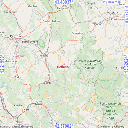
Sellano GPS coordinates[2]
42° 53' 14.46" North, 12° 55' 23.196" East
| Map corner | latitude | longitude |
|---|---|---|
| Upper-left | 43.40037°, | 12.21999° |
| Center: | 42.88735°, | 12.92311° |
| Lower-right: | 42.37002°, | 13.62624° |
| Map W x H: | 114.6×114.6 km | = 71.2×71.2mi |
| max Lat: | 47.04031° ⇑64% North |
| Sellano: | 42.88735° |
| min Lat: | ⇓36% South 35.50142° |
| min Long | Sellano | max Long |
| 6.69888° | 12.92311° | 18.48682° |
| W 67.4%⇐ | ⇒32.6% E |
Elevation
Elevation of Sellano is 629 m = 2064 ft, and this is 322.3 m = 1057 ft above average elevation for this country.
| Max E: |
2085 m = 6841 ft | 14.2% |
| Sellano | 629 m 2064 ft | |
| Avg. | 306.7 m = 1006 ft | |
Min E: |
-4 m = -13 ft | 85.8% |
See also: Italy elevation on elevation.city.
Geographical zone
Sellano is located in North temperate zone (between Tropic of Cancer and the Arctic Circle). Distance of this Northern Tropic circle is 2162.7 km =1343.8 mi to South.| Distance of | km | miles | from Sellano |
|---|---|---|---|
| North Pole | 5238.4 | 3255 | to North |
| Arctic Circle | 2632.5 | 1635.8 | to North |
| Tropic Cancer | 2162.7 | 1343.8 | to South |
| Equator | 4768.6 | 2963.1 | to South |


Nearby cities:
15 places around Sellano: (largest is in red/bold)
• Campello sul Clitunno
14.2 km =8.8 mi,  241°
241°
• Cannaiola
17.2 km =10.7 mi,  261°
261°
• Castelsantangelo sul Nera
18.9 km =11.7 mi,  87°
87°
• Cerreto di Spoleto
7.3 km =4.5 mi,  181°
181°
• Corciano-Pigge
14.7 km =9.1 mi,  253°
253°
• Fluminata
18.3 km =11.4 mi,  69°
69°
• Meggiano
15.5 km =9.6 mi,  198°
198°
• Norcia
17.7 km =11 mi,  127°
127°
• Pie' del Sasso
13.4 km =8.3 mi,  27°
27°
• Preci
9.3 km =5.8 mi, 94°
• San Giacomo
17.4 km =10.8 mi,  233°
233°
• Sant'Anatolia di Narco
18.6 km =11.6 mi, 202°
• Santa Maria in Valle
14.1 km =8.8 mi,  272°
272°
• Trevi
14.2 km =8.8 mi, 265°
• Visso
13.8 km =8.6 mi, 68°
Sources, notices
• [Note1] Compared only with cities in Italy existing in our database
• [Src1] Map data: © OpenStreetMap contributors (CC-BY-SA)
• [Src2] Other city data from geonames.org with taken over terms of usage.
• [Src3] Geographical zone / Annual Mean Temperature by Robert A. Rohde @ Wikipedia
