Visso geodata
Visso (The Marches) is a seat of a third-order administrative division; located in Italy in Europe/Rome (GMT+2) time zone. With population of 793 people, there are 7682 cities with bigger population in this country. Compared to other cities in Italy, 63.7% of cities are located further ↑North; 69.2% of cities are located further ←West and 84.6% of cities have lower elevation than Visso. Note1


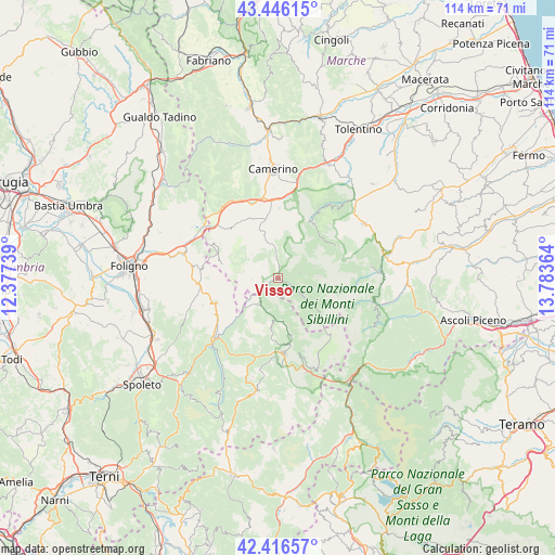
Visso GPS coordinates[2]
42° 56' 0.636" North, 13° 4' 49.836" East
| Map corner | latitude | longitude |
|---|---|---|
| Upper-left | 43.44615°, | 12.37739° |
| Center: | 42.93351°, | 13.08051° |
| Lower-right: | 42.41657°, | 13.78364° |
| Map W x H: | 114.5×114.5 km | = 71.1×71.1mi |
| max Lat: | 47.04031° ⇑63.7% North |
| Visso: | 42.93351° |
| min Lat: | ⇓36.3% South 35.50142° |
| min Long | Visso | max Long |
| 6.69888° | 13.08051° | 18.48682° |
| W 69.2%⇐ | ⇒30.8% E |
Elevation
Elevation of Visso is 603 m = 1978 ft, and this is 296.3 m = 972 ft above average elevation for this country.
| Max E: |
2085 m = 6841 ft | 15.4% |
| Visso | 603 m 1978 ft | |
| Avg. | 306.7 m = 1006 ft | |
Min E: |
-4 m = -13 ft | 84.6% |
See also: Italy elevation on elevation.city.
Geographical zone
Visso is located in North temperate zone (between Tropic of Cancer and the Arctic Circle). Distance of this Northern Tropic circle is 2167.8 km =1347 mi to South.| Distance of | km | miles | from Visso |
|---|---|---|---|
| North Pole | 5233.3 | 3251.8 | to North |
| Arctic Circle | 2627.4 | 1632.6 | to North |
| Tropic Cancer | 2167.8 | 1347 | to South |
| Equator | 4773.8 | 2966.3 | to South |


Nearby cities:
15 places around Visso: (largest is in red/bold)
• Bolognola
13.6 km =8.5 mi,  60°
60°
• Castelsantangelo sul Nera
7.5 km =4.7 mi,  126°
126°
• Cerreto di Spoleto
18 km =11.2 mi,  226°
226°
• Fluminata
4.6 km =2.9 mi,  75°
75°
• Muccia
16.8 km =10.4 mi,  349°
349°
• Norcia
15.9 km =9.9 mi,  175°
175°
• Pie' del Colle
13.2 km =8.2 mi,  35°
35°
• Pie' del Sasso
9.5 km =5.9 mi,  315°
315°
• Pieve Torina
12.5 km =7.8 mi, 347°
• Pievebovigliana
14.4 km =8.9 mi,  1°
1°
• Preci
6.8 km =4.2 mi,  210°
210°
• Sellano
13.8 km =8.6 mi,  248°
248°
• Serravalle di Chienti
18.6 km =11.6 mi,  325°
325°
• Trebbio
12.9 km =8 mi,  27°
27°
• Valle e Castello
11.6 km =7.2 mi, 2°
Sources, notices
• [Note1] Compared only with cities in Italy existing in our database
• [Src1] Map data: © OpenStreetMap contributors (CC-BY-SA)
• [Src2] Other city data from geonames.org with taken over terms of usage.
• [Src3] Geographical zone / Annual Mean Temperature by Robert A. Rohde @ Wikipedia
