Santa Maria in Valle geodata
Santa Maria in Valle (Umbria) is a populated place; located in Italy in Europe/Rome (GMT+2) time zone. With population of 617 people, there are 8865 cities with bigger population in this country. Compared to other cities in Italy, 64% of cities are located further ↑North; 65.6% of cities are located further ←West and 66.3% of cities have lower elevation than Santa Maria in Valle. Note1
Current local time in Santa Maria in Valle:
10:11 PM, WednesdayDifference from your time zone: hours


Santa Maria in Valle GPS coordinates[2]
42° 53' 34.584" North, 12° 44' 58.74" East
| Map corner | latitude | longitude |
|---|---|---|
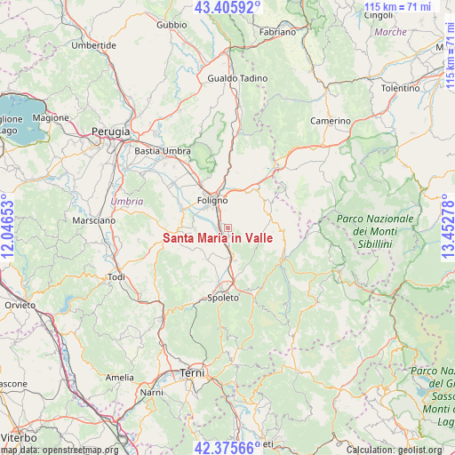
| Upper-left | 43.40592°, | 12.04653° |
| Center: | 42.89294°, | 12.74965° |
| Lower-right: | 42.37566°, | 13.45278° |
| Map W x H: | 114.6×114.6 km | = 71.2×71.2mi |
| max Lat: | 47.04031° ⇑64% North |
| Santa Maria in Valle: | 42.89294° |
| min Lat: | ⇓36% South 35.50142° |
| min Long | Santa Maria in | max Long |
| 6.69888° | 12.74965° | 18.48682° |
| W 65.6%⇐ | ⇒34.4% E |
Elevation
Elevation of Santa Maria in Valle is 356 m = 1168 ft, and this is 49.3 m = 162 ft above average elevation for this country.
| Max E: |
2085 m = 6841 ft | 33.7% |
| Santa Maria in Valle | 356 m 1168 ft | |
| Avg. | 306.7 m = 1006 ft | |
Min E: |
-4 m = -13 ft | 66.3% |
See also: Italy elevation on elevation.city.
Geographical zone
Santa Maria in Valle is located in North temperate zone (between Tropic of Cancer and the Arctic Circle). Distance of this Northern Tropic circle is 2163.3 km =1344.2 mi to South.| Distance of | km | miles | from Santa Maria in Valle |
|---|---|---|---|
| North Pole | 5237.8 | 3254.6 | to North |
| Arctic Circle | 2631.9 | 1635.4 | to North |
| Tropic Cancer | 2163.3 | 1344.2 | to South |
| Equator | 4769.2 | 2963.4 | to South |


Nearby cities:
15 places around Santa Maria in Valle: (largest is in red/bold)
• Bevagna
12 km =7.5 mi,  294°
294°
• Bruna
9.5 km =5.9 mi,  211°
211°
• Campello sul Clitunno
7.5 km =4.7 mi,  167°
167°
• Cannaiola
4.3 km =2.7 mi,  222°
222°
• Castel Ritaldi
10 km =6.2 mi, 218°
• Corciano-Pigge
4.8 km =3 mi,  179°
179°
• Cortaccione
14.4 km =8.9 mi, 177°
• Fiamenga
9.9 km =6.2 mi,  313°
313°
• Foligno
7.9 km =4.9 mi,  330°
330°
• Maceratola
9 km =5.6 mi, 314°
• Montefalco
8.3 km =5.2 mi,  268°
268°
• San Giacomo
11 km =6.8 mi, 178°
• Sellano
14.1 km =8.8 mi,  92°
92°
• Spello
13 km =8.1 mi, 328°
• Trevi
1.7 km =1.1 mi, 180°
Sources, notices
• [Note1] Compared only with cities in Italy existing in our database
• [Src1] Map data: © OpenStreetMap contributors (CC-BY-SA)
• [Src2] Other city data from geonames.org with taken over terms of usage.
• [Src3] Geographical zone / Annual Mean Temperature by Robert A. Rohde @ Wikipedia
