Castelsantangelo sul Nera geodata
Castelsantangelo sul Nera (The Marches) is a seat of a third-order administrative division; located in Italy in Europe/Rome (GMT+2) time zone. With population of 219 people, there are 11038 cities with bigger population in this country. Compared to other cities in Italy, 64% of cities are located further ↑North; 69.9% of cities are located further ←West and 90.6% of cities have lower elevation than Castelsantangelo sul Nera. Note1
Administrative division(s):
- Level 1: The Marches
- Level 2: Provincia di Macerata
- Level 3: Castelsantangelo sul Nera
Current local time in Castelsantangelo sul Nera:
09:40 PM, WednesdayDifference from your time zone: hours


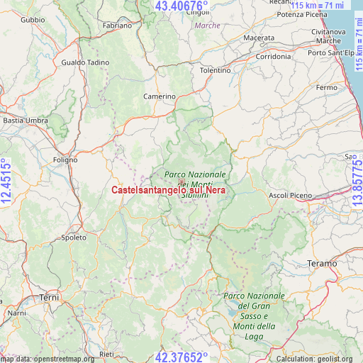
Castelsantangelo sul Nera GPS coordinates[2]
42° 53' 37.644" North, 13° 9' 16.632" East
| Map corner | latitude | longitude |
|---|---|---|
| Upper-left | 43.40676°, | 12.4515° |
| Center: | 42.89379°, | 13.15462° |
| Lower-right: | 42.37652°, | 13.85775° |
| Map W x H: | 114.6×114.6 km | = 71.2×71.2mi |
| max Lat: | 47.04031° ⇑64% North |
| Castelsantangelo sul Nera: | 42.89379° |
| min Lat: | ⇓36% South 35.50142° |
| min Long | Castelsantangel | max Long |
| 6.69888° | 13.15462° | 18.48682° |
| W 69.9%⇐ | ⇒30.1% E |
Elevation
Elevation of Castelsantangelo sul Nera is 735 m = 2411 ft, and this is 428.3 m = 1405 ft above average elevation for this country.
| Max E: |
2085 m = 6841 ft | 9.4% |
| Castelsantangelo sul Nera | 735 m 2411 ft | |
| Avg. | 306.7 m = 1006 ft | |
Min E: |
-4 m = -13 ft | 90.6% |
See also: Italy elevation on elevation.city.
Geographical zone
Castelsantangelo sul Nera is located in North temperate zone (between Tropic of Cancer and the Arctic Circle). Distance of this Northern Tropic circle is 2163.4 km =1344.3 mi to South.| Distance of | km | miles | from Castelsantangelo sul Nera |
|---|---|---|---|
| North Pole | 5237.7 | 3254.6 | to North |
| Arctic Circle | 2631.8 | 1635.3 | to North |
| Tropic Cancer | 2163.4 | 1344.3 | to South |
| Equator | 4769.3 | 2963.5 | to South |


Nearby cities:
15 places around Castelsantangelo sul Nera: (largest is in red/bold)
• Amandola
18.8 km =11.7 mi,  60°
60°
• Arquata del Tronto
17.7 km =11 mi,  140°
140°
• Balzo
15.6 km =9.7 mi,  111°
111°
• Bolognola
12.5 km =7.8 mi,  27°
27°
• Fluminata
5.8 km =3.6 mi,  343°
343°
• Montefortino
16.4 km =10.2 mi,  70°
70°
• Montemonaco
14.3 km =8.9 mi,  87°
87°
• Norcia
12.4 km =7.7 mi,  202°
202°
• Pie' del Colle
15.2 km =9.4 mi,  6°
6°
• Pie' del Sasso
16.9 km =10.5 mi,  311°
311°
• Pieve Torina
18.7 km =11.6 mi,  332°
332°
• Preci
9.7 km =6 mi,  261°
261°
• Trebbio
15.9 km =9.9 mi,  359°
359°
• Valle e Castello
16.9 km =10.5 mi, 341°
• Visso
7.5 km =4.7 mi, 306°
Sources, notices
• [Note1] Compared only with cities in Italy existing in our database
• [Src1] Map data: © OpenStreetMap contributors (CC-BY-SA)
• [Src2] Other city data from geonames.org with taken over terms of usage.
• [Src3] Geographical zone / Annual Mean Temperature by Robert A. Rohde @ Wikipedia
