Istia D'Ombrone-Le Stiacciole geodata
Istia D'Ombrone-Le Stiacciole (Tuscany) is a populated place; located in Italy in Europe/Rome (GMT+2) time zone. With population of 1,486 people, there are 5149 cities with bigger population in this country. Compared to other cities in Italy, 64.7% of cities are located further ↑North; 54.5% of cities are located further →East and 83.4% of cities have higher elevation than Istia D'Ombrone-Le Stiacciole. Note1
Current local time in Istia D'Ombrone-Le Stiacciole:
05:56 PM, WednesdayDifference from your time zone: hours


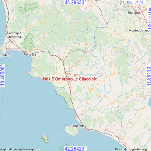
Istia D'Ombrone-Le Stiacciole GPS coordinates[2]
42° 46' 56.748" North, 11° 11' 17.52" East
| Map corner | latitude | longitude |
|---|---|---|
| Upper-left | 43.29633°, | 10.48508° |
| Center: | 42.78243°, | 11.1882° |
| Lower-right: | 42.26423°, | 11.89133° |
| Map W x H: | 114.8×114.8 km | = 71.3×71.3mi |
| max Lat: | 47.04031° ⇑64.7% North |
| Istia D'Ombrone-Le Stiacciole: | 42.78243° |
| min Lat: | ⇓35.3% South 35.50142° |
| min Long | Istia D'Ombrone | max Long |
| 6.69888° | 11.1882° | 18.48682° |
| W 45.5%⇐ | ⇒54.5% E |
Elevation
Elevation of Istia D'Ombrone-Le Stiacciole is 36 m = 118 ft, and this is 270.7 m = 888 ft below average elevation for this country.
| Max E: |
2085 m = 6841 ft | 83.4% |
| Avg. | 306.7 m = 1006 ft | |
| Istia D'Ombrone-Le Stiacciole | 36 m = 118 ft | |
Min E: |
-4 m = -13 ft | 16.6% |
See also: Italy elevation on elevation.city.
Geographical zone
Istia D'Ombrone-Le Stiacciole is located in North temperate zone (between Tropic of Cancer and the Arctic Circle). Distance of this Northern Tropic circle is 2151 km =1336.6 mi to South.| Distance of | km | miles | from Istia D'Ombrone-Le Stiacciole |
|---|---|---|---|
| North Pole | 5250.1 | 3262.3 | to North |
| Arctic Circle | 2644.2 | 1643 | to North |
| Tropic Cancer | 2151 | 1336.6 | to South |
| Equator | 4757 | 2955.9 | to South |


Nearby cities:
15 places around Istia D'Ombrone-Le Stiacciole: (largest is in red/bold)
• Bagno Roselle
5.2 km =3.2 mi,  308°
308°
• Batignano
9.5 km =5.9 mi,  349°
349°
• Braccagni
13.8 km =8.6 mi,  316°
316°
• Campagnatico
13.2 km =8.2 mi,  32°
32°
• Cinigiano
20.5 km =12.7 mi,  54°
54°
• Fonteblanda
24.2 km =15 mi,  182°
182°
• Grosseto
6.8 km =4.2 mi,  251°
251°
• Magliano in Toscana
22.2 km =13.8 mi,  157°
157°
• Marina di Grosseto
18.3 km =11.4 mi, 247°
• Montiano
15.5 km =9.6 mi,  169°
169°
• Paganico
18.2 km =11.3 mi,  21°
21°
• Ribolla
24.4 km =15.2 mi,  329°
329°
• Rispescia
9.4 km =5.8 mi,  206°
206°
• Scansano
15.6 km =9.7 mi,  132°
132°
• Sticciano Scalo
16.9 km =10.5 mi,  340°
340°
Sources, notices
• [Note1] Compared only with cities in Italy existing in our database
• [Src1] Map data: © OpenStreetMap contributors (CC-BY-SA)
• [Src2] Other city data from geonames.org with taken over terms of usage.
• [Src3] Geographical zone / Annual Mean Temperature by Robert A. Rohde @ Wikipedia
