Batignano geodata
Batignano (Tuscany) is a populated place; located in Italy in Europe/Rome (GMT+2) time zone. With population of 619 people, there are 8850 cities with bigger population in this country. Compared to other cities in Italy, 64.3% of cities are located further ↑North; 54.9% of cities are located further →East and 64.2% of cities have higher elevation than Batignano. Note1


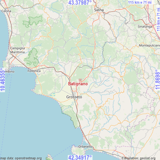
Batignano GPS coordinates[2]
42° 52' 0.012" North, 11° 10' 0.012" East
| Map corner | latitude | longitude |
|---|---|---|
| Upper-left | 43.37987°, | 10.46355° |
| Center: | 42.86667°, | 11.16667° |
| Lower-right: | 42.34917°, | 11.8698° |
| Map W x H: | 114.6×114.6 km | = 71.2×71.2mi |
| max Lat: | 47.04031° ⇑64.3% North |
| Batignano: | 42.86667° |
| min Lat: | ⇓35.7% South 35.50142° |
| min Long | Batignano | max Long |
| 6.69888° | 11.16667° | 18.48682° |
| W 45.1%⇐ | ⇒54.9% E |
Elevation
Elevation of Batignano is 133 m = 436 ft, and this is 173.7 m = 570 ft below average elevation for this country.
| Max E: |
2085 m = 6841 ft | 64.2% |
| Avg. | 306.7 m = 1006 ft | |
| Batignano | 133 m = 436 ft | |
Min E: |
-4 m = -13 ft | 35.8% |
See also: Italy elevation on elevation.city.
Geographical zone
Batignano is located in North temperate zone (between Tropic of Cancer and the Arctic Circle). Distance of this Northern Tropic circle is 2160.4 km =1342.4 mi to South.| Distance of | km | miles | from Batignano |
|---|---|---|---|
| North Pole | 5240.7 | 3256.4 | to North |
| Arctic Circle | 2634.8 | 1637.2 | to North |
| Tropic Cancer | 2160.4 | 1342.4 | to South |
| Equator | 4766.3 | 2961.6 | to South |


Nearby cities:
15 places around Batignano: (largest is in red/bold)
• Bagno Roselle
6.6 km =4.1 mi,  200°
200°
• Braccagni
7.7 km =4.8 mi,  275°
275°
• Caldana
19.9 km =12.4 mi, 278°
• Campagnatico
8.9 km =5.5 mi,  78°
78°
• Cinigiano
18.5 km =11.5 mi, 81°
• Civitella Marittima
17 km =10.6 mi,  33°
33°
• Grosseto
12.4 km =7.7 mi, 202°
• Istia D'Ombrone-Le Stiacciole
9.5 km =5.9 mi,  169°
169°
• Paganico
11.3 km =7 mi,  48°
48°
• Ribolla
15.8 km =9.8 mi,  317°
317°
• Rispescia
17.9 km =11.1 mi,  188°
188°
• Roccastrada
15.8 km =9.8 mi,  0°
0°
• Roccatederighi
19.2 km =11.9 mi,  338°
338°
• Sassofortino
18.3 km =11.4 mi,  345°
345°
• Sticciano Scalo
7.7 km =4.8 mi,  328°
328°
Sources, notices
• [Note1] Compared only with cities in Italy existing in our database
• [Src1] Map data: © OpenStreetMap contributors (CC-BY-SA)
• [Src2] Other city data from geonames.org with taken over terms of usage.
• [Src3] Geographical zone / Annual Mean Temperature by Robert A. Rohde @ Wikipedia
