Santo Stefano di Cadore geodata
Santo Stefano di Cadore (Veneto) is a seat of a third-order administrative division; located in Italy in Europe/Rome (GMT+2) time zone. With population of 1,218 people, there are 5899 cities with bigger population in this country. Compared to other cities in Italy, 98.7% of cities are located further ↓South; 63% of cities are located further ←West and 95.7% of cities have lower elevation than Santo Stefano di Cadore. Note1
Administrative division(s):
- Level 1: Veneto
- Level 2: Provincia di Belluno
- Level 3: Santo Stefano di Cadore
Current local time in Santo Stefano di Cadore:
01:23 AM, MondayDifference from your time zone: hours


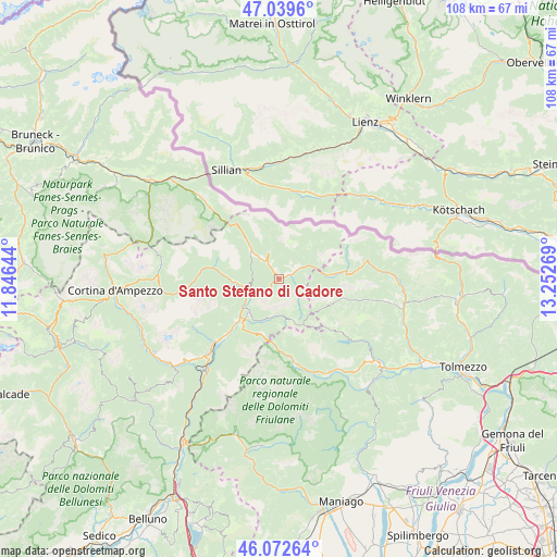
Santo Stefano di Cadore GPS coordinates[2]
46° 33' 29.772" North, 12° 32' 58.416" East
| Map corner | latitude | longitude |
|---|---|---|
| Upper-left | 47.0396°, | 11.84644° |
| Center: | 46.55827°, | 12.54956° |
| Lower-right: | 46.07264°, | 13.25269° |
| Map W x H: | 107.5×107.5 km | = 66.8×66.8mi |
| max Lat: | 47.04031° ⇑1.3% North |
| Santo Stefano di Cadore: | 46.55827° |
| min Lat: | ⇓98.7% South 35.50142° |
| min Long | Santo Stefano d | max Long |
| 6.69888° | 12.54956° | 18.48682° |
| W 63%⇐ | ⇒37% E |
Elevation
Elevation of Santo Stefano di Cadore is 913 m = 2995 ft, and this is 606.3 m = 1989 ft above average elevation for this country.
| Max E: |
2085 m = 6841 ft | 4.3% |
| Santo Stefano di Cadore | 913 m 2995 ft | |
| Avg. | 306.7 m = 1006 ft | |
Min E: |
-4 m = -13 ft | 95.7% |
See also: Italy elevation on elevation.city.
Geographical zone
Santo Stefano di Cadore is located in North temperate zone (between Tropic of Cancer and the Arctic Circle). Distance of this North polar circle is 2224.4 km =1382.2 mi to North.| Distance of | km | miles | from Santo Stefano di Cadore |
|---|---|---|---|
| North Pole | 4830.3 | 3001.4 | to North |
| Arctic Circle | 2224.4 | 1382.2 | to North |
| Tropic Cancer | 2570.9 | 1597.5 | to South |
| Equator | 5176.8 | 3216.7 | to South |


Nearby cities:
15 places around Santo Stefano di Cadore: (largest is in red/bold)
• Auronzo
9.6 km =6 mi,  270°
270°
• Campolongo
2.5 km =1.6 mi,  73°
73°
• Candide
4.3 km =2.7 mi,  322°
322°
• Danta
2.4 km =1.5 mi,  293°
293°
• Forni di Sopra
15.6 km =9.7 mi,  170°
170°
• Granvilla
10.7 km =6.6 mi,  84°
84°
• Laggio di Cadore
8.7 km =5.4 mi,  217°
217°
• Lorenzago di Cadore
11.1 km =6.9 mi, 218°
• Lozzo di Cadore
11.3 km =7 mi,  225°
225°
• Padola
7.3 km =4.5 mi,  313°
313°
• San Nicolò Comelico
3.2 km =2 mi,  327°
327°
• San Pietro di Cadore
3.2 km =2 mi,  62°
62°
• Sappada
10.3 km =6.4 mi, 84°
• Vico
15.1 km =9.4 mi, 169°
• Vigo di Cadore
8.9 km =5.5 mi, 222°
Sources, notices
• [Note1] Compared only with cities in Italy existing in our database
• [Src1] Map data: © OpenStreetMap contributors (CC-BY-SA)
• [Src2] Other city data from geonames.org with taken over terms of usage.
• [Src3] Geographical zone / Annual Mean Temperature by Robert A. Rohde @ Wikipedia
