Auronzo geodata
Auronzo (Veneto) is a seat of a third-order administrative division; located in Italy in Europe/Rome (GMT+2) time zone. With population of 3,347 people, there are 2802 cities with bigger population in this country. Compared to other cities in Italy, 98.7% of cities are located further ↓South; 61.6% of cities are located further ←West and 95.2% of cities have lower elevation than Auronzo. Note1
Administrative division(s):
- Level 1: Veneto
- Level 2: Provincia di Belluno
- Level 3: Auronzo di Cadore


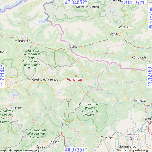
Auronzo GPS coordinates[2]
46° 33' 33.12" North, 12° 25' 28.416" East
| Map corner | latitude | longitude |
|---|---|---|
| Upper-left | 47.04052°, | 11.72144° |
| Center: | 46.5592°, | 12.42456° |
| Lower-right: | 46.07357°, | 13.12769° |
| Map W x H: | 107.5×107.5 km | = 66.8×66.8mi |
| max Lat: | 47.04031° ⇑1.3% North |
| Auronzo: | 46.5592° |
| min Lat: | ⇓98.7% South 35.50142° |
| min Long | Auronzo | max Long |
| 6.69888° | 12.42456° | 18.48682° |
| W 61.6%⇐ | ⇒38.4% E |
Elevation
Elevation of Auronzo is 887 m = 2910 ft, and this is 580.3 m = 1904 ft above average elevation for this country.
| Max E: |
2085 m = 6841 ft | 4.8% |
| Auronzo | 887 m 2910 ft | |
| Avg. | 306.7 m = 1006 ft | |
Min E: |
-4 m = -13 ft | 95.2% |
See also: Italy elevation on elevation.city.
Geographical zone
Auronzo is located in North temperate zone (between Tropic of Cancer and the Arctic Circle). Distance of this North polar circle is 2224.3 km =1382.1 mi to North.| Distance of | km | miles | from Auronzo |
|---|---|---|---|
| North Pole | 4830.2 | 3001.3 | to North |
| Arctic Circle | 2224.3 | 1382.1 | to North |
| Tropic Cancer | 2571 | 1597.5 | to South |
| Equator | 5176.9 | 3216.8 | to South |


Nearby cities:
15 places around Auronzo: (largest is in red/bold)
• Calalzo di Cadore
13 km =8.1 mi,  194°
194°
• Campolongo
12 km =7.5 mi,  87°
87°
• Candide
7.7 km =4.8 mi,  64°
64°
• Danta
7.4 km =4.6 mi,  83°
83°
• Domegge di Cadore
11.5 km =7.1 mi, 186°
• Laggio di Cadore
8.2 km =5.1 mi,  148°
148°
• Lorenzago di Cadore
9.3 km =5.8 mi,  163°
163°
• Lozzo di Cadore
8.2 km =5.1 mi,  169°
169°
• Padola
6.5 km =4 mi,  40°
40°
• Pozzale
14.4 km =8.9 mi,  198°
198°
• San Giuseppe
15.2 km =9.4 mi,  343°
343°
• San Nicolò Comelico
8.3 km =5.2 mi,  71°
71°
• San Pietro di Cadore
12.5 km =7.8 mi, 83°
• Santo Stefano di Cadore
9.6 km =6 mi, 90°
• Vigo di Cadore
7.6 km =4.7 mi, 151°
Sources, notices
• [Note1] Compared only with cities in Italy existing in our database
• [Src1] Map data: © OpenStreetMap contributors (CC-BY-SA)
• [Src2] Other city data from geonames.org with taken over terms of usage.
• [Src3] Geographical zone / Annual Mean Temperature by Robert A. Rohde @ Wikipedia
