Castagnole geodata
Castagnole (Veneto) is a populated place; located in Italy in Europe/Rome (GMT+2) time zone. With population of 2,983 people, there are 3061 cities with bigger population in this country. Compared to other cities in Italy, 80.6% of cities are located further ↓South; 58.4% of cities are located further ←West and 85.6% of cities have higher elevation than Castagnole. Note1


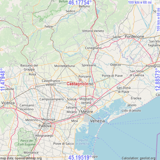
Castagnole GPS coordinates[2]
45° 41' 18.672" North, 12° 10' 57.36" East
| Map corner | latitude | longitude |
|---|---|---|
| Upper-left | 46.17754°, | 11.47948° |
| Center: | 45.68852°, | 12.1826° |
| Lower-right: | 45.19519°, | 12.88573° |
| Map W x H: | 109.2×109.2 km | = 67.9×67.9mi |
| max Lat: | 47.04031° ⇑19.4% North |
| Castagnole: | 45.68852° |
| min Lat: | ⇓80.6% South 35.50142° |
| min Long | Castagnole | max Long |
| 6.69888° | 12.1826° | 18.48682° |
| W 58.4%⇐ | ⇒41.6% E |
Elevation
Elevation of Castagnole is 29 m = 95 ft, and this is 277.7 m = 911 ft below average elevation for this country.
| Max E: |
2085 m = 6841 ft | 85.6% |
| Avg. | 306.7 m = 1006 ft | |
| Castagnole | 29 m = 95 ft | |
Min E: |
-4 m = -13 ft | 14.4% |
See also: Italy elevation on elevation.city.
Geographical zone
Castagnole is located in North temperate zone (between Tropic of Cancer and the Arctic Circle). Distance of this North polar circle is 2321.1 km =1442.3 mi to North.| Distance of | km | miles | from Castagnole |
|---|---|---|---|
| North Pole | 4927 | 3061.5 | to North |
| Arctic Circle | 2321.1 | 1442.3 | to North |
| Tropic Cancer | 2474.2 | 1537.4 | to South |
| Equator | 5080.1 | 3156.6 | to South |


Nearby cities:
15 places around Castagnole: (largest is in red/bold)
• Camalò
7.2 km =4.5 mi,  353°
353°
• Istrana
6.5 km =4 mi,  258°
258°
• Lancenigo-Villorba
6.4 km =4 mi,  64°
64°
• Musano
6.6 km =4.1 mi,  309°
309°
• Padernello
4.4 km =2.7 mi, 259°
• Paese
2.2 km =1.4 mi,  222°
222°
• Pezzan
6.7 km =4.2 mi,  274°
274°
• Ponzano
3.4 km =2.1 mi,  29°
29°
• Porcellengo
3.7 km =2.3 mi,  301°
301°
• Postioma
4 km =2.5 mi,  323°
323°
• Quinto di Treviso
5.2 km =3.2 mi,  195°
195°
• Sala
7 km =4.3 mi,  283°
283°
• Santa Cristina
6 km =3.7 mi,  214°
214°
• Santandrà
6.7 km =4.2 mi,  12°
12°
• Treviso
5.2 km =3.2 mi,  117°
117°
Sources, notices
• [Note1] Compared only with cities in Italy existing in our database
• [Src1] Map data: © OpenStreetMap contributors (CC-BY-SA)
• [Src2] Other city data from geonames.org with taken over terms of usage.
• [Src3] Geographical zone / Annual Mean Temperature by Robert A. Rohde @ Wikipedia
