Ponticelli geodata
Ponticelli (Campania) is a populated place; located in Italy in Europe/Rome (GMT+2) time zone. With population of 52,284 people, there are 110 cities with bigger population in this country. Compared to other cities in Italy, 80.7% of cities are located further ↑North; 81.1% of cities are located further ←West and 86.1% of cities have higher elevation than Ponticelli. Note1
Administrative division(s):
- Level 1: Campania
- Level 2: Napoli
- Level 3: Napoli
- Level 4: Municipalità 6


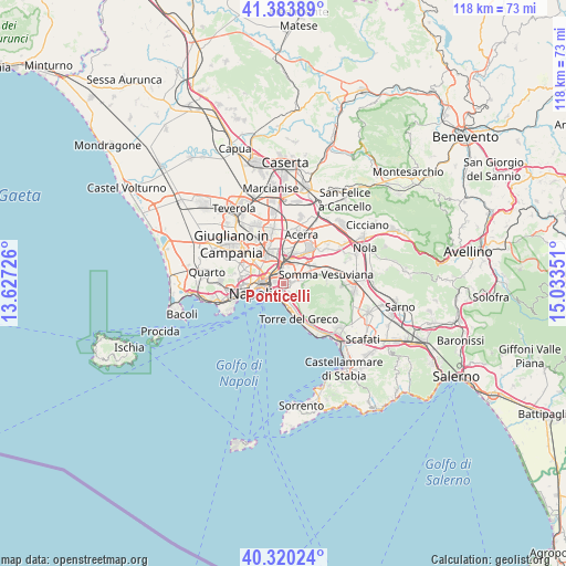
Ponticelli GPS coordinates[2]
40° 51' 15.12" North, 14° 19' 49.368" East
| Map corner | latitude | longitude |
|---|---|---|
| Upper-left | 41.38389°, | 13.62726° |
| Center: | 40.8542°, | 14.33038° |
| Lower-right: | 40.32024°, | 15.03351° |
| Map W x H: | 118.3×118.3 km | = 73.5×73.5mi |
| max Lat: | 47.04031° ⇑80.7% North |
| Ponticelli: | 40.8542° |
| min Lat: | ⇓19.3% South 35.50142° |
| min Long | Ponticelli | max Long |
| 6.69888° | 14.33038° | 18.48682° |
| W 81.1%⇐ | ⇒18.9% E |
Elevation
Elevation of Ponticelli is 28 m = 92 ft, and this is 278.7 m = 914 ft below average elevation for this country.
| Max E: |
2085 m = 6841 ft | 86.1% |
| Avg. | 306.7 m = 1006 ft | |
| Ponticelli | 28 m = 92 ft | |
Min E: |
-4 m = -13 ft | 13.9% |
See also: Ponticelli elevation on elevation.city.
Geographical zone
Ponticelli is located in North temperate zone (between Tropic of Cancer and the Arctic Circle). Distance of this Northern Tropic circle is 1936.6 km =1203.3 mi to South.| Distance of | km | miles | from Ponticelli |
|---|---|---|---|
| North Pole | 5464.5 | 3395.5 | to North |
| Arctic Circle | 2858.6 | 1776.3 | to North |
| Tropic Cancer | 1936.6 | 1203.3 | to South |
| Equator | 4542.6 | 2822.6 | to South |


Nearby cities:
15 places around Ponticelli: (largest is in red/bold)
• Arpino
3.9 km =2.4 mi,  347°
347°
• Barra
1.6 km =1 mi,  217°
217°
• Casarea
4.7 km =2.9 mi,  36°
36°
• Cercola
2.4 km =1.5 mi,  73°
73°
• Massa di Somma
3.9 km =2.4 mi,  104°
104°
• Musci
4 km =2.5 mi,  47°
47°
• Poggioreale
3.7 km =2.3 mi,  289°
289°
• Pollena Trocchia
4.1 km =2.5 mi,  94°
94°
• Portici
4.3 km =2.7 mi,  172°
172°
• San Giorgio a Cremano
2.6 km =1.6 mi,  158°
158°
• San Giovanni a Teduccio
2.7 km =1.7 mi,  228°
228°
• San Sebastiano al Vesuvio
3.1 km =1.9 mi,  112°
112°
• Vicaria
4.9 km =3 mi,  279°
279°
• Volla
2.3 km =1.4 mi,  22°
22°
• Zona Industriale
4 km =2.5 mi,  259°
259°
Sources, notices
• [Note1] Compared only with cities in Italy existing in our database
• [Src1] Map data: © OpenStreetMap contributors (CC-BY-SA)
• [Src2] Other city data from geonames.org with taken over terms of usage.
• [Src3] Geographical zone / Annual Mean Temperature by Robert A. Rohde @ Wikipedia
