Volla geodata
Volla (Campania) is a seat of a third-order administrative division; located in Italy in Europe/Rome (GMT+2) time zone. With population of 22,911 people, there are 372 cities with bigger population in this country. Compared to other cities in Italy, 80.4% of cities are located further ↑North; 81.2% of cities are located further ←West and 86.7% of cities have higher elevation than Volla. Note1


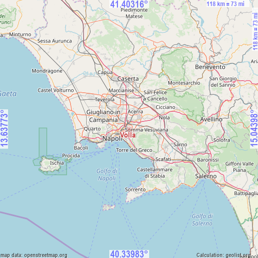
Volla GPS coordinates[2]
40° 52' 25.068" North, 14° 20' 27.06" East
| Map corner | latitude | longitude |
|---|---|---|
| Upper-left | 41.40316°, | 13.63773° |
| Center: | 40.87363°, | 14.34085° |
| Lower-right: | 40.33983°, | 15.04398° |
| Map W x H: | 118.2×118.2 km | = 73.4×73.4mi |
| max Lat: | 47.04031° ⇑80.4% North |
| Volla: | 40.87363° |
| min Lat: | ⇓19.6% South 35.50142° |
| min Long | Volla | max Long |
| 6.69888° | 14.34085° | 18.48682° |
| W 81.2%⇐ | ⇒18.8% E |
Elevation
Elevation of Volla is 26 m = 85 ft, and this is 280.7 m = 921 ft below average elevation for this country.
| Max E: |
2085 m = 6841 ft | 86.7% |
| Avg. | 306.7 m = 1006 ft | |
| Volla | 26 m = 85 ft | |
Min E: |
-4 m = -13 ft | 13.3% |
See also: Italy elevation on elevation.city.
Geographical zone
Volla is located in North temperate zone (between Tropic of Cancer and the Arctic Circle). Distance of this Northern Tropic circle is 1938.8 km =1204.7 mi to South.| Distance of | km | miles | from Volla |
|---|---|---|---|
| North Pole | 5462.3 | 3394.1 | to North |
| Arctic Circle | 2856.5 | 1774.9 | to North |
| Tropic Cancer | 1938.8 | 1204.7 | to South |
| Equator | 4544.7 | 2823.9 | to South |


Nearby cities:
15 places around Volla: (largest is in red/bold)
• Arpino
2.4 km =1.5 mi,  314°
314°
• Barra
3.9 km =2.4 mi,  208°
208°
• Casalnuovo di Napoli
4 km =2.5 mi,  1°
1°
• Casarea
2.5 km =1.6 mi,  49°
49°
• Cercola
2 km =1.2 mi,  136°
136°
• Massa di Somma
4.3 km =2.7 mi, 137°
• Musci
2.2 km =1.4 mi,  75°
75°
• Poggioreale
4.5 km =2.8 mi,  258°
258°
• Pollena Trocchia
4.1 km =2.5 mi,  127°
127°
• Ponte di Ferro
4.7 km =2.9 mi,  73°
73°
• Ponticelli
2.3 km =1.4 mi,  202°
202°
• San Giorgio a Cremano
4.6 km =2.9 mi,  179°
179°
• San Giovanni a Teduccio
4.9 km =3 mi,  216°
216°
• San Pietro a Patierno
4.5 km =2.8 mi,  287°
287°
• San Sebastiano al Vesuvio
3.9 km =2.4 mi,  149°
149°
Sources, notices
• [Note1] Compared only with cities in Italy existing in our database
• [Src1] Map data: © OpenStreetMap contributors (CC-BY-SA)
• [Src2] Other city data from geonames.org with taken over terms of usage.
• [Src3] Geographical zone / Annual Mean Temperature by Robert A. Rohde @ Wikipedia
