San Sebastiano al Vesuvio geodata
San Sebastiano al Vesuvio (Campania) is a seat of a third-order administrative division; located in Italy in Europe/Rome (GMT+2) time zone. With population of 9,167 people, there are 1035 cities with bigger population in this country. Compared to other cities in Italy, 80.9% of cities are located further ↑North; 81.4% of cities are located further ←West and 62.9% of cities have higher elevation than San Sebastiano al Vesuvio. Note1
Current local time in San Sebastiano al Vesuvio:
09:38 PM, WednesdayDifference from your time zone: hours


San Sebastiano al Vesuvio GPS coordinates[2]
40° 50' 36.384" North, 14° 21' 51.408" East
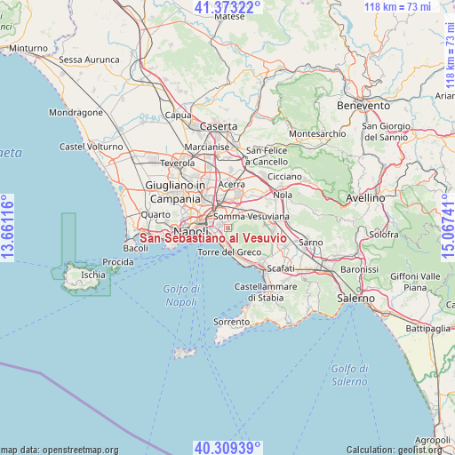
| Map corner | latitude | longitude |
|---|---|---|
| Upper-left | 41.37322°, | 13.66116° |
| Center: | 40.84344°, | 14.36428° |
| Lower-right: | 40.30939°, | 15.06741° |
| Map W x H: | 118.3×118.3 km | = 73.5×73.5mi |
| max Lat: | 47.04031° ⇑80.9% North |
| San Sebastiano al Vesuvio: | 40.84344° |
| min Lat: | ⇓19.1% South 35.50142° |
| min Long | San Sebastiano | max Long |
| 6.69888° | 14.36428° | 18.48682° |
| W 81.4%⇐ | ⇒18.6% E |
Elevation
Elevation of San Sebastiano al Vesuvio is 142 m = 466 ft, and this is 164.7 m = 540 ft below average elevation for this country.
| Max E: |
2085 m = 6841 ft | 62.9% |
| Avg. | 306.7 m = 1006 ft | |
| San Sebastiano al Vesuvio | 142 m = 466 ft | |
Min E: |
-4 m = -13 ft | 37.1% |
See also: Italy elevation on elevation.city.
Geographical zone
San Sebastiano al Vesuvio is located in North temperate zone (between Tropic of Cancer and the Arctic Circle). Distance of this Northern Tropic circle is 1935.4 km =1202.6 mi to South.| Distance of | km | miles | from San Sebastiano al Vesuvio |
|---|---|---|---|
| North Pole | 5465.7 | 3396.2 | to North |
| Arctic Circle | 2859.8 | 1777 | to North |
| Tropic Cancer | 1935.4 | 1202.6 | to South |
| Equator | 4541.4 | 2821.9 | to South |


Nearby cities:
15 places around San Sebastiano al Vesuvio: (largest is in red/bold)
• Barra
3.9 km =2.4 mi,  268°
268°
• Casarea
5 km =3.1 mi,  359°
359°
• Cercola
2 km =1.2 mi,  342°
342°
• Ercolano
4.1 km =2.5 mi,  196°
196°
• Massa di Somma
0.9 km =0.6 mi,  75°
75°
• Musci
3.9 km =2.4 mi,  2°
2°
• Pollena Trocchia
1.5 km =0.9 mi,  54°
54°
• Ponte di Ferro
5.3 km =3.3 mi,  28°
28°
• Ponticelli
3.1 km =1.9 mi,  292°
292°
• Portici
3.8 km =2.4 mi,  216°
216°
• San Giorgio a Cremano
2.3 km =1.4 mi,  237°
237°
• San Giovanni a Teduccio
4.9 km =3 mi,  263°
263°
• Sant'Anastasia
4.2 km =2.6 mi, 48°
• Torre del Greco
6 km =3.7 mi,  176°
176°
• Volla
3.9 km =2.4 mi,  329°
329°
Sources, notices
• [Note1] Compared only with cities in Italy existing in our database
• [Src1] Map data: © OpenStreetMap contributors (CC-BY-SA)
• [Src2] Other city data from geonames.org with taken over terms of usage.
• [Src3] Geographical zone / Annual Mean Temperature by Robert A. Rohde @ Wikipedia
