Venezzano geodata
Venezzano (Emilia-Romagna) is a populated place; located in Italy in Europe/Rome (GMT+2) time zone. With population of 1,531 people, there are 5051 cities with bigger population in this country. Compared to other cities in Italy, 53.9% of cities are located further ↓South; 52.7% of cities are located further →East and 92.6% of cities have higher elevation than Venezzano. Note1


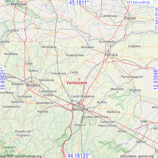
Venezzano GPS coordinates[2]
44° 40' 59.988" North, 11° 19' 59.988" East
| Map corner | latitude | longitude |
|---|---|---|
| Upper-left | 45.1811°, | 10.63021° |
| Center: | 44.68333°, | 11.33333° |
| Lower-right: | 44.18125°, | 12.03646° |
| Map W x H: | 111.2×111.2 km | = 69.1×69.1mi |
| max Lat: | 47.04031° ⇑46.1% North |
| Venezzano: | 44.68333° |
| min Lat: | ⇓53.9% South 35.50142° |
| min Long | Venezzano | max Long |
| 6.69888° | 11.33333° | 18.48682° |
| W 47.3%⇐ | ⇒52.7% E |
Elevation
Elevation of Venezzano is 13 m = 43 ft, and this is 293.7 m = 964 ft below average elevation for this country.
| Max E: |
2085 m = 6841 ft | 92.6% |
| Avg. | 306.7 m = 1006 ft | |
| Venezzano | 13 m = 43 ft | |
Min E: |
-4 m = -13 ft | 7.4% |
See also: Italy elevation on elevation.city.
Geographical zone
Venezzano is located in North temperate zone (between Tropic of Cancer and the Arctic Circle). Distance of this Northern Tropic circle is 2362.4 km =1467.9 mi to South.| Distance of | km | miles | from Venezzano |
|---|---|---|---|
| North Pole | 5038.7 | 3130.9 | to North |
| Arctic Circle | 2432.9 | 1511.7 | to North |
| Tropic Cancer | 2362.4 | 1467.9 | to South |
| Equator | 4968.3 | 3087.2 | to South |


Nearby cities:
15 places around Venezzano: (largest is in red/bold)
• Argelato
4.9 km =3 mi,  170°
170°
• Bentivoglio
8.4 km =5.2 mi,  127°
127°
• Castagnolo Minore
9.2 km =5.7 mi,  155°
155°
• Castello d'Argile
2.9 km =1.8 mi,  258°
258°
• Cento
6.4 km =4 mi,  325°
325°
• Corpo Reno
8.3 km =5.2 mi,  346°
346°
• Decima
8.7 km =5.4 mi,  290°
290°
• Galliera
8.8 km =5.5 mi,  32°
32°
• Maccaretolo
8.6 km =5.3 mi,  63°
63°
• Padulle
7.4 km =4.6 mi,  216°
216°
• Pieve di Cento
3.8 km =2.4 mi, 329°
• San Giorgio di Piano
5.2 km =3.2 mi,  140°
140°
• San Pietro in Casale
6 km =3.7 mi,  71°
71°
• Santa Maria in Duno
8 km =5 mi, 139°
• Stiatico
7.5 km =4.7 mi, 162°
Sources, notices
• [Note1] Compared only with cities in Italy existing in our database
• [Src1] Map data: © OpenStreetMap contributors (CC-BY-SA)
• [Src2] Other city data from geonames.org with taken over terms of usage.
• [Src3] Geographical zone / Annual Mean Temperature by Robert A. Rohde @ Wikipedia
