Decima geodata
Decima (Emilia-Romagna) is a populated place; located in Italy in Europe/Rome (GMT+2) time zone. With population of 5,181 people, there are 1887 cities with bigger population in this country. Compared to other cities in Italy, 54.4% of cities are located further ↓South; 54% of cities are located further →East and 90.1% of cities have higher elevation than Decima. Note1
Administrative division(s):
- Level 1: Emilia-Romagna
- Level 2: Bologna
- Level 3: San Giovanni in Persiceto


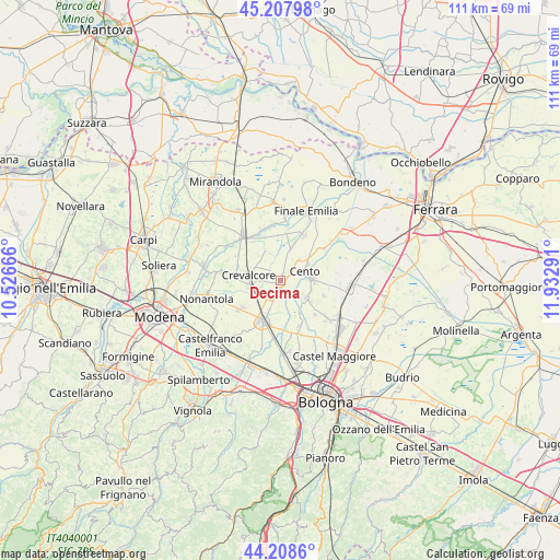
Decima GPS coordinates[2]
44° 42' 37.62" North, 11° 13' 47.208" East
| Map corner | latitude | longitude |
|---|---|---|
| Upper-left | 45.20798°, | 10.52666° |
| Center: | 44.71045°, | 11.22978° |
| Lower-right: | 44.2086°, | 11.93291° |
| Map W x H: | 111.1×111.1 km | = 69×69mi |
| max Lat: | 47.04031° ⇑45.6% North |
| Decima: | 44.71045° |
| min Lat: | ⇓54.4% South 35.50142° |
| min Long | Decima | max Long |
| 6.69888° | 11.22978° | 18.48682° |
| W 46%⇐ | ⇒54% E |
Elevation
Elevation of Decima is 18 m = 59 ft, and this is 288.7 m = 947 ft below average elevation for this country.
| Max E: |
2085 m = 6841 ft | 90.1% |
| Avg. | 306.7 m = 1006 ft | |
| Decima | 18 m = 59 ft | |
Min E: |
-4 m = -13 ft | 9.9% |
See also: Italy elevation on elevation.city.
Geographical zone
Decima is located in North temperate zone (between Tropic of Cancer and the Arctic Circle). Distance of this Northern Tropic circle is 2365.4 km =1469.8 mi to South.| Distance of | km | miles | from Decima |
|---|---|---|---|
| North Pole | 5035.7 | 3129 | to North |
| Arctic Circle | 2429.8 | 1509.8 | to North |
| Tropic Cancer | 2365.4 | 1469.8 | to South |
| Equator | 4971.3 | 3089 | to South |


Nearby cities:
15 places around Decima: (largest is in red/bold)
• Castello d'Argile
6.4 km =4 mi,  124°
124°
• Cento
5.1 km =3.2 mi,  63°
63°
• Corpo Reno
8 km =5 mi,  50°
50°
• Crevalcore
6.6 km =4.1 mi,  278°
278°
• Dodici Morelli
10.3 km =6.4 mi,  28°
28°
• Dosso
10.8 km =6.7 mi, 53°
• Padulle
9.8 km =6.1 mi,  157°
157°
• Palata Pepoli
9.1 km =5.7 mi,  1°
1°
• Pieve di Cento
6.3 km =3.9 mi,  87°
87°
• Ravarino
10.7 km =6.6 mi, 278°
• Renazzo
7.5 km =4.7 mi,  36°
36°
• Sala Bolognese
10.9 km =6.8 mi,  168°
168°
• San Giovanni in Persiceto
8.8 km =5.5 mi,  204°
204°
• Sant'Agata Bolognese
9.5 km =5.9 mi,  233°
233°
• Venezzano
8.7 km =5.4 mi,  110°
110°
Sources, notices
• [Note1] Compared only with cities in Italy existing in our database
• [Src1] Map data: © OpenStreetMap contributors (CC-BY-SA)
• [Src2] Other city data from geonames.org with taken over terms of usage.
• [Src3] Geographical zone / Annual Mean Temperature by Robert A. Rohde @ Wikipedia
