Bentivoglio geodata
Bentivoglio (Emilia-Romagna) is a seat of a third-order administrative division; located in Italy in Europe/Rome (GMT+2) time zone. With population of 1,234 people, there are 5847 cities with bigger population in this country. Compared to other cities in Italy, 53.2% of cities are located further ↓South; 51.6% of cities are located further →East and 92.6% of cities have higher elevation than Bentivoglio. Note1


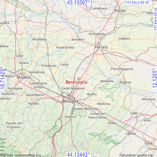
Bentivoglio GPS coordinates[2]
44° 38' 12.84" North, 11° 25' 2.532" East
| Map corner | latitude | longitude |
|---|---|---|
| Upper-left | 45.13507°, | 10.71425° |
| Center: | 44.6369°, | 11.41737° |
| Lower-right: | 44.13442°, | 12.1205° |
| Map W x H: | 111.3×111.3 km | = 69.2×69.2mi |
| max Lat: | 47.04031° ⇑46.8% North |
| Bentivoglio: | 44.6369° |
| min Lat: | ⇓53.2% South 35.50142° |
| min Long | Bentivoglio | max Long |
| 6.69888° | 11.41737° | 18.48682° |
| W 48.4%⇐ | ⇒51.6% E |
Elevation
Elevation of Bentivoglio is 13 m = 43 ft, and this is 293.7 m = 964 ft below average elevation for this country.
| Max E: |
2085 m = 6841 ft | 92.6% |
| Avg. | 306.7 m = 1006 ft | |
| Bentivoglio | 13 m = 43 ft | |
Min E: |
-4 m = -13 ft | 7.4% |
See also: Italy elevation on elevation.city.
Geographical zone
Bentivoglio is located in North temperate zone (between Tropic of Cancer and the Arctic Circle). Distance of this Northern Tropic circle is 2357.2 km =1464.7 mi to South.| Distance of | km | miles | from Bentivoglio |
|---|---|---|---|
| North Pole | 5043.9 | 3134.1 | to North |
| Arctic Circle | 2438 | 1514.9 | to North |
| Tropic Cancer | 2357.2 | 1464.7 | to South |
| Equator | 4963.2 | 3084 | to South |


Nearby cities:
15 places around Bentivoglio: (largest is in red/bold)
• Altedo
6.9 km =4.3 mi,  56°
56°
• Argelato
5.8 km =3.6 mi,  273°
273°
• Castagnolo Minore
4.3 km =2.7 mi,  221°
221°
• Castel Maggiore
8 km =5 mi,  213°
213°
• Cà Dè Fabbri
3.5 km =2.2 mi,  122°
122°
• Lovoleto
5.6 km =3.5 mi,  172°
172°
• Minerbio
4.8 km =3 mi, 115°
• Pegola
8.9 km =5.5 mi,  47°
47°
• Progresso
8.7 km =5.4 mi, 209°
• San Giorgio di Piano
3.6 km =2.2 mi,  288°
288°
• San Marino
3.6 km =2.2 mi, 174°
• San Pietro in Casale
7.2 km =4.5 mi,  352°
352°
• Santa Maria in Duno
1.8 km =1.1 mi,  238°
238°
• Stiatico
4.9 km =3 mi,  245°
245°
• Venezzano
8.4 km =5.2 mi,  307°
307°
Sources, notices
• [Note1] Compared only with cities in Italy existing in our database
• [Src1] Map data: © OpenStreetMap contributors (CC-BY-SA)
• [Src2] Other city data from geonames.org with taken over terms of usage.
• [Src3] Geographical zone / Annual Mean Temperature by Robert A. Rohde @ Wikipedia
