Cento geodata
Cento (Emilia-Romagna) is a seat of a third-order administrative division; located in Italy in Europe/Rome (GMT+2) time zone. With population of 18,191 people, there are 484 cities with bigger population in this country. Compared to other cities in Italy, 54.9% of cities are located further ↓South; 53.3% of cities are located further →East and 90.6% of cities have higher elevation than Cento. Note1


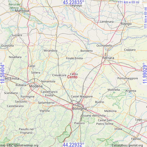
Cento GPS coordinates[2]
44° 43' 51.564" North, 11° 17' 13.776" East
| Map corner | latitude | longitude |
|---|---|---|
| Upper-left | 45.22835°, | 10.58404° |
| Center: | 44.73099°, | 11.28716° |
| Lower-right: | 44.22932°, | 11.99029° |
| Map W x H: | 111.1×111.1 km | = 69×69mi |
| max Lat: | 47.04031° ⇑45.1% North |
| Cento: | 44.73099° |
| min Lat: | ⇓54.9% South 35.50142° |
| min Long | Cento | max Long |
| 6.69888° | 11.28716° | 18.48682° |
| W 46.7%⇐ | ⇒53.3% E |
Elevation
Elevation of Cento is 17 m = 56 ft, and this is 289.7 m = 950 ft below average elevation for this country.
| Max E: |
2085 m = 6841 ft | 90.6% |
| Avg. | 306.7 m = 1006 ft | |
| Cento | 17 m = 56 ft | |
Min E: |
-4 m = -13 ft | 9.4% |
See also: Italy elevation on elevation.city.
Geographical zone
Cento is located in North temperate zone (between Tropic of Cancer and the Arctic Circle). Distance of this Northern Tropic circle is 2367.7 km =1471.2 mi to South.| Distance of | km | miles | from Cento |
|---|---|---|---|
| North Pole | 5033.4 | 3127.6 | to North |
| Arctic Circle | 2427.6 | 1508.4 | to North |
| Tropic Cancer | 2367.7 | 1471.2 | to South |
| Equator | 4973.6 | 3090.5 | to South |


Nearby cities:
15 places around Cento: (largest is in red/bold)
• Argelato
11 km =6.8 mi,  156°
156°
• Castello d'Argile
5.9 km =3.7 mi,  172°
172°
• Corpo Reno
3.2 km =2 mi,  30°
30°
• Crevalcore
11.1 km =6.9 mi,  263°
263°
• Decima
5.1 km =3.2 mi,  243°
243°
• Dodici Morelli
6.8 km =4.2 mi,  2°
2°
• Dosso
5.8 km =3.6 mi,  45°
45°
• Galliera
8.7 km =5.4 mi,  76°
76°
• Padulle
11.3 km =7 mi,  183°
183°
• Palata Pepoli
8 km =5 mi,  327°
327°
• Pieve di Cento
2.7 km =1.7 mi,  139°
139°
• Renazzo
3.8 km =2.4 mi,  358°
358°
• San Pietro in Casale
9.9 km =6.2 mi,  109°
109°
• Sant'Agostino
10.3 km =6.4 mi, 48°
• Venezzano
6.4 km =4 mi,  145°
145°
Sources, notices
• [Note1] Compared only with cities in Italy existing in our database
• [Src1] Map data: © OpenStreetMap contributors (CC-BY-SA)
• [Src2] Other city data from geonames.org with taken over terms of usage.
• [Src3] Geographical zone / Annual Mean Temperature by Robert A. Rohde @ Wikipedia
