San Giorgio a Cremano geodata
San Giorgio a Cremano (Campania) is a seat of a third-order administrative division; located in Italy in Europe/Rome (GMT+2) time zone. With population of 45,463 people, there are 150 cities with bigger population in this country. Compared to other cities in Italy, 81% of cities are located further ↑North; 81.2% of cities are located further ←West and 77.5% of cities have higher elevation than San Giorgio a Cremano. Note1
Current local time in San Giorgio a Cremano:
11:02 PM, WednesdayDifference from your time zone: hours


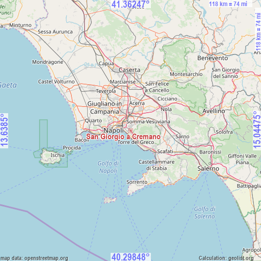
San Giorgio a Cremano GPS coordinates[2]
40° 49' 57.396" North, 14° 20' 29.832" East
| Map corner | latitude | longitude |
|---|---|---|
| Upper-left | 41.36247°, | 13.6385° |
| Center: | 40.83261°, | 14.34162° |
| Lower-right: | 40.29848°, | 15.04475° |
| Map W x H: | 118.3×118.3 km | = 73.5×73.5mi |
| max Lat: | 47.04031° ⇑81% North |
| San Giorgio a Cremano: | 40.83261° |
| min Lat: | ⇓19% South 35.50142° |
| min Long | San Giorgio a C | max Long |
| 6.69888° | 14.34162° | 18.48682° |
| W 81.2%⇐ | ⇒18.8% E |
Elevation
Elevation of San Giorgio a Cremano is 62 m = 203 ft, and this is 244.7 m = 803 ft below average elevation for this country.
| Max E: |
2085 m = 6841 ft | 77.5% |
| Avg. | 306.7 m = 1006 ft | |
| San Giorgio a Cremano | 62 m = 203 ft | |
Min E: |
-4 m = -13 ft | 22.5% |
See also: San Giorgio a Cremano elevation on elevation.city.
Geographical zone
San Giorgio a Cremano is located in North temperate zone (between Tropic of Cancer and the Arctic Circle). Distance of this Northern Tropic circle is 1934.2 km =1201.9 mi to South.| Distance of | km | miles | from San Giorgio a Cremano |
|---|---|---|---|
| North Pole | 5466.9 | 3397 | to North |
| Arctic Circle | 2861 | 1777.7 | to North |
| Tropic Cancer | 1934.2 | 1201.9 | to South |
| Equator | 4540.2 | 2821.1 | to South |


Nearby cities:
15 places around San Giorgio a Cremano: (largest is in red/bold)
• Barra
2.2 km =1.4 mi,  299°
299°
• Cercola
3.4 km =2.1 mi,  23°
23°
• Ercolano
2.8 km =1.7 mi,  165°
165°
• Massa di Somma
3.2 km =2 mi,  63°
63°
• Mercato
6 km =3.7 mi,  283°
283°
• Musci
5.5 km =3.4 mi, 21°
• Poggioreale
5.8 km =3.6 mi,  309°
309°
• Pollena Trocchia
3.8 km =2.4 mi, 56°
• Ponticelli
2.6 km =1.6 mi,  338°
338°
• Portici
1.9 km =1.2 mi,  191°
191°
• San Giovanni a Teduccio
3.1 km =1.9 mi, 281°
• San Sebastiano al Vesuvio
2.3 km =1.4 mi, 57°
• Torre del Greco
5.3 km =3.3 mi,  155°
155°
• Volla
4.6 km =2.9 mi,  359°
359°
• Zona Industriale
5.2 km =3.2 mi,  289°
289°
Sources, notices
• [Note1] Compared only with cities in Italy existing in our database
• [Src1] Map data: © OpenStreetMap contributors (CC-BY-SA)
• [Src2] Other city data from geonames.org with taken over terms of usage.
• [Src3] Geographical zone / Annual Mean Temperature by Robert A. Rohde @ Wikipedia
